They say we know more about the surface of the Moon than we do about the bottom of the ocean, but it still might surprise you to learn that we only just officially recognized one of Earth’s continents in 2017. Known as Te Riu-a-Māui, or Zealandia, it’s sandwiched between Australia, Eurasia, and North America, and it represents the youngest, smallest, and thinnest of Earth’s continents.
Zealandia sits in the Southern Hemisphere and is around 5 million square kilometers (1.9 million square miles) big, but 95 percent of it is hidden underwater. What we do see of it surface-side is New Zealand and New Caledonia, home to some of the planet’s most remarkable scenery. Like they say: quality, not quantity.
A new review set out to explore what we’ve discovered about this newcomer to the recognized cast of continents, looking at what we know so far about its tectonic history, crustal structure, and geological evolution. Looking at decades of research, it tracked Zealandia from its Gondwanan origins all the way to the modern era, and it makes for quite the story.
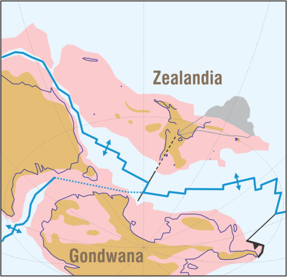
“This is the most comprehensive review yet of the geology of the 5 million square kilometre, 95% submerged, Zealandia continent,” Dr Nick Mortimer, Emeritus Geologist at GNS Science and the author of this review, said. “For most of the past 500 million years, Zealandia was part of the southern supercontinent of Gondwana. Then, 85 to 60 million years ago, Zealandia split from Gondwana to become its own continent. Since its maximum drowning 25 million years ago, movements at plate boundaries have built up the North and South Islands.”
Zealandia stands out from Earth’s other continents in having only very small landmasses with very wide submarine continental shelves. This is why so much of it is underwater compared to the other continents that have large landmasses and narrow submarine continental shelves.

Zealandia’s exit strategy when the time came to go it alone ~80 million years ago.
Image credit: Dr Nick Mortimer
We already know that it is geologically complex and that the boundary between the Pacific and Australia tectonic plates cuts right across it. This explains why it is we see frequent earthquakes and explosive volcanism in certain regions, making it a valuable resource for understanding the risk of future natural hazards, as well as the continent’s geological past.
“Notwithstanding incredibly valuable drill core and oceanic island samples, it is Zealandia that represents our largest source of material samples relating to the tectonic, oceanographic, climatic and biologic development of the Pacific hemisphere,” James Crampton, Professor of Paleontology and Stratigraphy, Te Herenga Waka Victoria University of Wellington, who was not involved in the study, said. “Zealandia’s stratigraphic archive records the history of planet-driving ocean-climate systems and of unique plants and animals – Aotearoa’s living taonga.”
“Importantly, Zealandian strata document the causes and regional impacts of perturbations on the Earth system – natural experiments that reveal the responses of our life, oceans, and climate to disturbances of varied scale, cause and rate. The geological record of Zealandia is a globally critical piece in the Earth system puzzle.”
Zealandia as a continent is something that’s been hypothesized for around 150 years, but it’s only recently that we’ve been able to gather the evidence needed to confirm as much. Mortimer reckons this is largely thanks to the advent of satellite technology and marine geological data, and now that we’re building our arsenal to better study the planet, there’s plenty more we have to discover about this newcomer.
“We’ve answered a lot of the ‘what, when, and how’ questions but many ‘whys’ are still unknown,” says Mortimer. “Such as ‘Why did the Gondwana supercontinent break up?’ and ‘Why are there so many extinct volcanoes scattered across Zealandia?’”
The study is published in the New Zealand Journal of Geology and Geophysics.
Source Link: 95 Percent Of The World’s Youngest, Smallest, And Most Mysterious Continent Is Underwater