A “La Niña watch” has been issued by the Aussie Bureau of Meteorology after hints of change were noted in the tropical Pacific Ocean.
Conditions in the Pacific are currently considered neutral, but the weather agency states there’s evidence that La Niña may form in the Pacific Ocean later in 2024, the Bureau of Meteorology said in an announcement on May 14.
The bureau switched to La Niña watch after noticing how sea surface temperatures in the central Pacific have been steadily cooling since December 2023. When these criteria have been met in the past, they said, a La Niña event has developed around 50 percent of the time.
The El Niño-Southern Oscillation cycle is a pattern of climate fluctuations in the Pacific that alternates between El Niño – the warmer phase – and La Niña – the cooler phase.
Although located in the central and eastern tropical Pacific Ocean, the change in temperatures has a knock-on effect across the world, impacting everything from wind, temperature, and rainfall patterns to the intensity of hurricane seasons and even the distribution of fish in the seas.

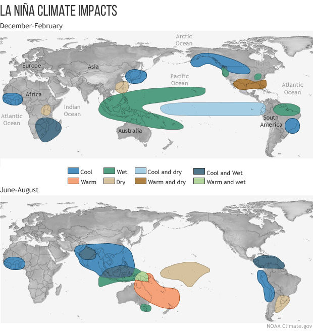
Map showing how La Niña phase impacts the weather and climate of the world differently.
Image credit: NOAA
Effects on weather vary from region to region, but El Niño phases typically create higher average global temperatures, raising the chances of record-breaking warm years. However, even in the presence of the cooling La Niña phase, several of the past years in recent history have broken heat records due to climate change.
The past year – 2023 to 2024 – has been marked by a particularly strong El Niño phase. The warmer waters cause the Pacific jet stream to move south and extend, causing drier and warmer weather to hit northern parts of the US and Canada, but wetter weather in southern states. Over in Australia, El Niño typically promotes hotter temperatures, as well as reduced rainfall in the east and north of the country.
Prior to this, the planet was embraced with a rare triple-dip La Niña that lasted from 2020–2023. During the La Niña phase, we see the opposite of El Niño. The cold waters in the Pacific push the jet stream northward, resulting in drier weather in the southern US, but notably wetter and colder weather in the Pacific Northwest and Canada.
Australia is particularly wary of the return of La Niña as it was linked to substantial flooding across eastern Australia in 2021 and 2022.
The Australian Bureau of Meteorology is not the only forecaster predicting the possible return of La Niña later this year. The US National Weather Service’s Climate Prediction Center said in its May forecast that there’s a 49 percent chance that La Niña will develop during the June to August period, rising to 69 percent in July to September. The Japanese weather agency also said there’s a 60 percent chance that La Niña conditions will develop by boreal autumn (September to November).
Source Link: A "La Niña Watch" Warning Has Been Issued By Australia's Bureau Of Meteorology