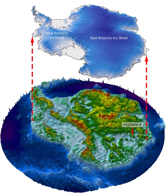
An ancient landscape that has remained hidden beneath the East Antarctic Ice Sheet (EAIS) for at least 14 million years has been revealed by a new satellite data and radar imaging study. According to the researchers, the preservation of this primordial scenery attests to the fact that the EAIS has remained relatively unchanged for eons, yet this stability could soon be threatened by an unprecedented rise in global temperatures.
The study authors used satellite data to identify undulations in the ice sheet’s surface that provided clues as to the nature of the terrain beneath. Using radio-echo sounding techniques, they were then able to image the landscape covered by the ice over an area of 32,000 square kilometers (12,355 square miles).
“The land underneath the East Antarctic Ice Sheet is less well known than the surface of Mars,” explained study author Professor Stewart Jamieson in a statement. “And that’s a problem because that landscape controls the way that ice in Antarctica flows, and it controls the way it might respond to past, present and future climate change.”
Analyzing their data, the researchers identified three river-carved upland blocks separated by deep U-shaped valleys. It’s likely that the waterways that formed this landscape flowed during and after the break-up of the Gondwana supercontinent, before the first glaciers appeared and helped erode the valleys to a depth of around 800 meters (2,625 feet).

The river valleys and highlands are situated about 350 kilometers (217 miles) from the edge of the ice sheet.
Image credit: Stewart Jamieson
“What we find is an ancient land surface that has not been eroded by the ice sheet and instead it looks like it was created by rivers before the ice came along,” said Jamieson. “This tells us that there hasn’t been a lot of change in this particular area, which indicates that although this part of the ice sheet may have retreated during warmer times in the past, the conditions at this site likely did not change much, and that helps us understand how the ice sheet might respond to future and ongoing warming.”
In their write-up, the study authors explain that the landscape has probably been encased in ice for at least 14 million years. During this period, the warmest temperatures occurred about three million years ago in the mid-Piacenzian warm period, yet the most reliable ice sheet models suggest that the EAIS didn’t retreat as far as this river landscape.
It’s even possible that the ancient scenery formed as far back as 34 million years ago, when the EAIS first appeared following the Eocene-Oligocene transition (EOT) from warm to glacial conditions. However, it’s unclear if the ice sheet has ever retreated far enough during this period to expose and alter the three river valleys, which lie some 350 kilometers (217 miles) from the edge of the EAIS.
“The age of the land surface is uncertain, but it is likely to predate the mid-Miocene [14 million years ago] and perhaps dates from the transition from warm to glacial conditions in Antarctica following the EOT,” write the researchers. “The survival of the landscape implies a long-term stable basal thermal regime and that the ice margin is unlikely to have retreated as far inland as this locality during warm periods of the last 14 [million years].”
Moreover, these findings indicate that the temperature increase of the mid-Piacenzian warm period was insufficient to cause the EAIS to retreat as far as this ancient landscape. However, the study authors warn “we are now on course to develop atmospheric conditions similar to those that prevailed between 34 and 14 [million years ago] […] between now and 2100 under continued fossil fuel burning.”
Unless this is halted, the long-term stability of the EAIS could soon be a thing of the past.
The study is published in the journal Nature Communications.
Source Link: Ancient Landscape Not Seen For 14 Million Years Discovered Beneath Antarctic Ice