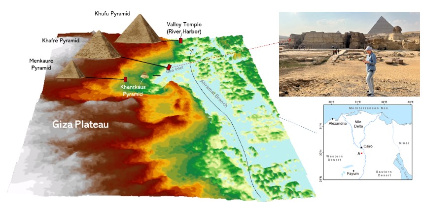
The mystery of how the pyramids were built may have finally been solved thanks to the discovery of an ancient branch of the Nile that once flowed through Giza. Hundreds of meters wide, the enormous waterway has long since dried up, but could have provided transportation for the colossal amounts of material and workers needed to construct the iconic landmarks thousands of years ago.
According to the researchers, the clustering of pyramids along the western desert margin of the Nile floodplain indicates that the area may once have been served by a large watercourse capable of supporting ambitious construction projects. Speaking to IFLScience, study author Dr Eman Ghoneim said that “if there are pyramids everywhere in this specific area, there must have been in the past water bodies that carried or facilitated the transportation of rocks and large numbers of workmen to these sites.”
“So we know that there was a waterway, there was a highway that the ancient Egyptians used to use, but no one knows where it was,” she explained. “How big was this branch [of the Nile]? Where exactly was this branch? How close was this branch to the actual pyramid sites?”
To find out, Ghoneim had to zoom out as far as possible, using radar satellite data to survey the Nile Valley from space. Because radar waves are able to penetrate the ground, the images provided access to an “invisible world of information beneath the surface”, revealing the presence of a dried-up riverbed that snakes through the desert and agricultural land for about 100 kilometers (62 miles).
“The length probably was really, really long, but also the width of this branch in some areas was huge,” said Ghoneim. “We’re talking about half a kilometer or more in terms of width, which is something that is equivalent to today’s Nile course width.”
“So it wasn’t a small branch. It was a major branch.”

Left: illustration revealing how the pyramids’ causeways and harbors align perfectly with the ancient Nile branch. Top right: A causeway in Giza that once led down to the waterfront.
Image credit: Eman Ghoneim
Running from Faiyum to Giza, the defunct waterway passes through 38 different pyramid sites and has therefore been dubbed the Ahramat Branch (meaning Pyramid Branch in Arabic) by the researchers. The team now plans to analyze soil cores from the ancient riverbed in order to determine if it was active during the Old and Middle Kingdoms (3,700 to 4,700 years ago), when the pyramids were built.
Without this confirmation, it’s impossible to draw any firm conclusions, although there are a number of smoking guns that suggest the branch did indeed play a role in the monuments’ construction. For instance, Ghoneim explained that “most of these pyramids used to have a causeway that ends usually with what we call a valley temple, which is like a harbor or ancient port.”
Most of these valley temples are “located exactly at the bank of the branch that we found,” she said.
In addition to providing new insights into the construction of the pyramids, the exploration of ancient Nile branches could also help archaeologists uncover the secrets of Ancient Egypt by assisting in the location of other lost sites, Ghoneim said. “Over time, the main course of the Nile has migrated – in some areas east, in some places west – because rivers always do that,” she explained.
“As branches disappeared, Ancient Egyptian cities and towns also silted up and disappeared, and we have no clue actually where to find them.” By following the course of ancient waterways, she said, researchers stand a better chance of discovering these old settlements, all of which will help “to understand our history, the Egyptian heritage.”
The research was presented at the 13th International Congress of Egyptologists earlier this year.
Source Link: Discovery Of Ancient Waterway May Solve Mystery Of How The Pyramids Were Built