It’s looking increasingly likely that El Niño is on its way. In turn, this could have major implications for weather patterns worldwide as well as some worrying consequences for the climate crisis.
The latest NOAA update has stated that El Niño is “knocking on the door” with above-average surface temperatures rising in the tropical Pacific, affirming previous warnings from the World Meteorological Organization (WMO).
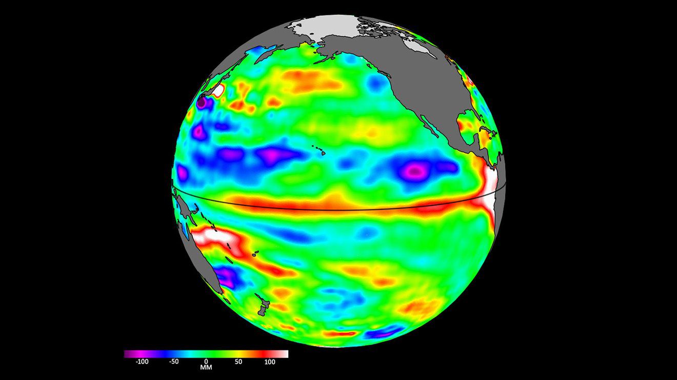
Simultaneously, satellite images have shown the emergence of “Kelvin waves” in the Pacific, a potential indication that El Niño conditions are brewing in the ocean.
The El Niño-Southern Oscillation (ENSO) cycle describes how a pattern of climate fluctuations in the Pacific Ocean has a global impact on the world – from wind, temperature, and rainfall patterns to the intensity of hurricane seasons and even the distribution of fish in the seas.
Every couple of years or so, conditions can flip from El Niño – the “warm phase” of the ENSO – to La Niña – the “cooling phase” – and vice versa. During El Niño, winds along the equator are weaker. Warm water is pushed back east toward the west coast of the Americas. As a result, less cold water rises toward the surface.
An indication of El Niño? Data from the Sentinel-6 Michael Freilich satellite on April 24 shows relatively higher (shown in red and white) and warmer ocean water at the equator and the west coast of South America.
Image credit: NASA/JPL-Caltech
The global impact of this is profound. The warmer waters cause the Pacific jet stream to move south and extend, causing drier and warmer weather to hit northern parts of the US and Canada, but wetter weather in southern states.
We’ve been in the midst of continuing La Niña events since September 2020, but 2023 saw tides starting to turn with conditions widely predicted to flip over to El Niño.
The big fear is that El Niño conditions over the coming years have the potential to raise global average temperatures, which are one of the main gauges used to measure climate change. If this brewing El Niño is a big one, 2023 and 2024 could experience a string of unprecedented heat waves and push global average temperatures into record-breaking territory.
“Given how warm the oceans are already, a developing El Niño would only increase the chance of record-breaking global ocean temperatures (and global average temperature over both ocean and land), which likely would have important ecological consequences, including for fish and corals,” said NOAA.
Over in Australia, other worrying trends could be afoot. El Niño typically suppresses rainfall in eastern Australia during the winter and spring months, meaning drier weather and a higher risk of wildfires.
It’s notoriously tough to predict how the ENSO will pan out, but news of the ongoing trends in the Pacific has got scientists observing the situation with bated breath.
“We’ll be watching this El Niño like a hawk,” Josh Willis, Sentinel-6 Michael Freilich project scientist at NASA’s Jet Propulsion Laboratory in Southern California, said in a statement.
“If it’s a big one, the globe will see record warming, but here in the Southwest U.S. we could be looking at another wet winter, right on the heels of the soaking we got last winter.”
Source Link: El Niño Is “Knocking On The Door” – Threatening A Worrying Trend For 2023 and 2024
