The world’s climate is in crisis, and it is important to monitor potential tipping points: critical thresholds that, when breached, can lead to snowballing and potentially irreversible changes. As part of an attempt to understand how the ocean melts Antarctica’s ice shelves, researchers sent a remotely operated vehicle (ROV) called Ran underneath the Dotson ice shelf in West Antarctica, to map the region using sonar.
“We have previously used satellite data and ice cores to observe how glaciers change over time,” lead author Anna Wåhlin, Professor of Oceanography at the University of Gothenburg, said in a statement. “By navigating the submersible into the cavity, we were able to get high resolution maps of the ice underside. It’s a bit like seeing the back of the moon.”
During the expedition, which took place in 2022, the ROV traveled over 1,000 kilometers (621 miles) back and forth under the glacier, reaching 17 kilometers (10.5 miles) into a cavity within the ice.
“Better models are needed to predict how fast the ice shelves will melt in the future. It is exciting when oceanographers and glaciologists work together, combining remote sensing with oceanographic field data,” Wåhlin said. “This is needed to understand the glaciological changes taking place – the driving force is in the ocean.”
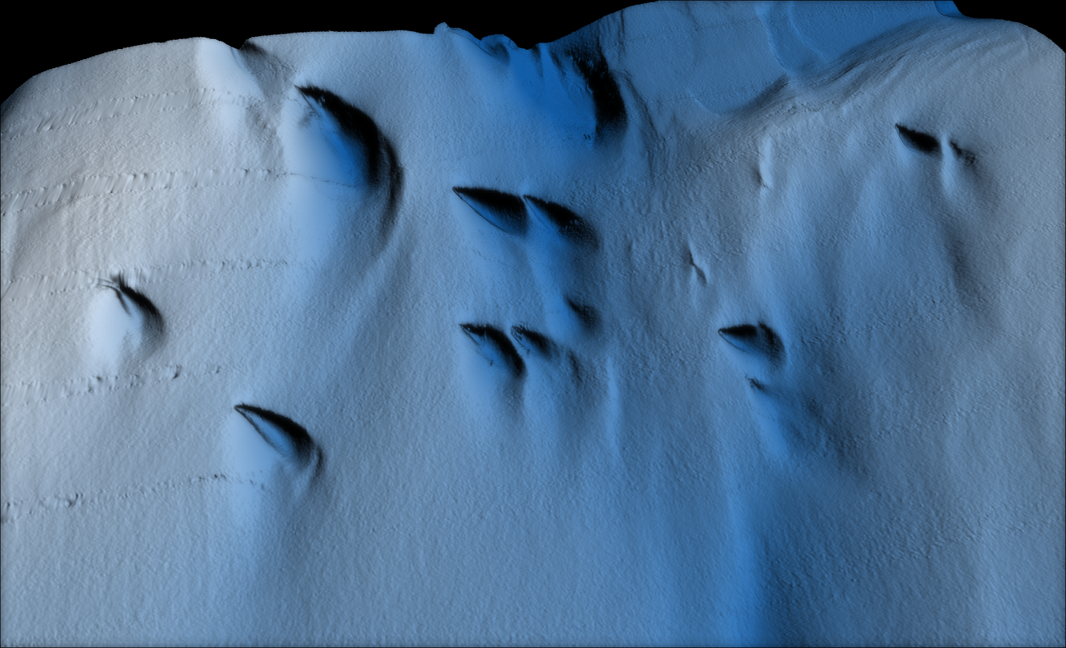
The team has now published the results of the survey, including some interesting finds. One such find was strange patterns of peaks and valleys at the glacier’s base, where underwater currents are slowly eroding it and moving further into the cracks. What was especially odd was that coming out of these rougher-than-expected peaks and valleys were features resembling sand dunes, stretching up to 400 meters (1,300 feet) long. Analyzing the features, the team believes that they are the result of the movement of water on the underside of the glacier due to the Earth’s rotation.
“If you look closely at the shapes they are not symmetrical, they are bent a bit like blue mussels, and the reason for that asymmetry is Earth’s rotation,” Wåhlin told Live Science. “Water moving on Earth is subject to something called the Coriolis force, which is acting to the left of the direction of motion in the Southern Hemisphere. If we are correct, there is a force balance in the layer closest to the ice where friction is balanced by the Coriolis force.”
The pattern of water that appears to have created this pattern is known as an Ekman Spiral.

A visualization of the features seen by the drone.
Image Credit: Filip Stedt / University of Gothenburg, Courtesy of Anna Wåhlin
“When surface water molecules move by the force of the wind, they, in turn, drag deeper layers of water molecules below them. Each layer of water molecules is moved by friction from the shallower layer, and each deeper layer moves more slowly than the layer above it, until the movement ceases at a depth of about 100 meters (330 feet),” the National Oceanic and Atmospheric Administration (NOAA) explains on their website.
The deeper water is affected by the Coriolis effect, with plumes spreading asymmetrically according to which hemisphere you are in. In the northern hemisphere, the plume spreads to the right; in the southern hemisphere, to the left.
“As a result, each successively deeper layer of water moves more slowly to the right or left, creating a spiral effect. Because the deeper layers of water move more slowly than the shallower layers, they tend to ‘twist around’ and flow opposite to the surface current,” NOAA continues.
The team notes that the older “teardrop” shapes had tails more parallel to the flow, as expected using Ekman theory, but adds that more observations are needed.

The ROV surfacing after venturing into the depths in 2022.
Image Credit: Anna Wåhlin / University of Gothenburg, Courtesy of Anna Wåhlin
Unfortunately, since this expedition, the submersible has gone missing underneath the Doomsday Glacier. During dives, the submersible does not have constant contact with the researchers operating it. Instead, the AUV follows a pre-programmed route and uses an advanced navigation system to find its way back from underneath the ice to open water.
However, after several successful dives underneath the ice, during one trip in January of 2024, Ran failed to appear at the rendezvous point. Despite searches with acoustic equipment, drones, and helicopters, the team has been unable to locate Ran since.
“It’s a bit like looking for a needle in a haystack, but without even knowing where the haystack is,” Wåhlin said in a statement in January. “At this point, Ran’s batteries are dead. All we know is that something unexpected happened under the ice. We suspect it ran into trouble, and then something prevented it from getting out.”
The team believes this is likely sadly the end for Ran, though they note it is a better end for the submersible than aging and gathering dust in a garage. They now plan on replacing the submersible and continuing its important research.
The study is published in the journal Science Advances: Oceanography.
Source Link: Giant Structures Found Underneath Antarctic Ice By Now-Missing Underwater Drone