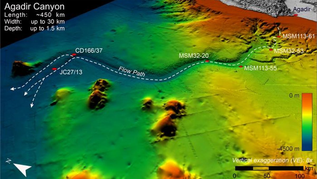
In a big result for “Isn’t it crazy what science can figure out?!” news, researchers from the University of Liverpool have revealed the evolution and incredible destruction wrought by a gigantic underwater avalanche nearly 60,000 years ago.
The team used more than 300 core samples, taken from the seafloor of the Atlantic Ocean off the North West coast of Africa over the past 40 years. Combining this with seismic and bathymetry data from the area, they were able to map out the path of the avalanche as it grew from a small underwater landslide into a devastating climactic event.
“This is the first time anyone has managed to map out an entire individual underwater avalanche of this size and calculate its growth factor,” said Chris Stevenson, a sedimentologist from the University of Liverpool’s School of Environmental Sciences and co-leader of the team, in a statement.
“What is so interesting is how the event grew from a relatively small start into a huge and devastating submarine avalanche,” he explained, “reaching heights of 200 meters [656 feet] as it moved at a speed of about 15 m/s [49 feet/second] ripping out the sea floor and tearing everything out in its way.”
Starting at just 1.5 cubic kilometers (0.36 cubic miles) in volume, it snowballed (or, rather, gravel-, sand-, and mud-balled) into a huge and powerful avalanche, capable of eroding 400 kilometers (249 miles) along one of the largest submarine canyons in the world, the Agadir Canyon, as well as around 4,500 square kilometers (1,738 square miles) of the canyon walls.
“To put it in perspective: that’s an avalanche the size of a skyscraper, moving at more than 40 mph [64 kmph] from Liverpool to London, which digs out a trench 30 m [98 feet] deep and 15 km [9.3 miles] wide destroying everything in its path,” Stevenson said. “Then it spreads across an area larger than the UK burying it under about a meter of sand and mud.”
It’s a really impressive result, not least because underwater avalanches are so mysterious even when they happen today. They’re impossible to see, and extremely hard to measure; predicting when they will occur or how damaging they will be is equally difficult. Building this picture of an ancient underwater avalanche isn’t only useful for what it can tell us about the past, therefore: it provides important data about how powerful such events can be, how they can occur, and how much of a threat they can be when they do.
“Our new insight fundamentally challenges how we view these events,” said Sebastian Krastel, head of Marine Geophysics at Kiel University and chief scientist aboard the cruises that mapped the canyon. “Before this study, we thought that big avalanches only came from big slope failures. But now, we know that they can start small and grow into extremely powerful and extensive giant events.”
Indeed, this prehistoric avalanche grew by a factor some 12-25 times larger than a normal snow or debris avalanche: “We calculate the growth factor to be at least 100,” explained Christoph Bottner, a Marie-Curie research fellow at Aarhus University in Denmark and co-leader of the team.
“We have also seen this extreme growth in smaller submarine avalanches measured elsewhere,” Bottner added, “so we think this might be a specific behavior associated with underwater avalanches and is something we plan to investigate further.”
And that’s very good news. While unseen and almost unmeasurable avalanches thousands of meters below the waves may seem like an esoteric and niche subject, the truth is that such events have the potential to disrupt life for all of us.
Why? One reason: undersea internet cables.
“These findings are of enormous importance for how we try and assess their potential geohazard risk to seafloor infrastructure,” Stevenson explained, “like internet cables that carry almost all global internet traffic, which are critical to all aspects of our modern societies.”
The study is published in the journal Science Advances.
Source Link: Gigantic, Devastating Ancient Underwater Avalanche Mapped In World-First Result