With summer storm season continuing to bubble up in the planet’s northern hemisphere, you might be unfortunate enough to come across a derecho.
A derecho – which means “straight ahead” in Spanish – is loosely defined as a widespread, long-lived wind storm that has a strip of rapidly moving thunderstorms that can prove devastating for anything left in its way.
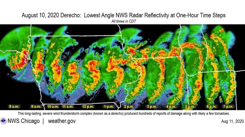
The rare form of storm is effectively like a tidal wave of aggressive winds and rain that pushes across the land, often in a bow-shaped strip (image below). This situation stands in contrast to hurricanes that form around a central “eye” with rotational winds that create a swirling circular shape.
The National Weather Service states derechos are associated with wind gusts of at least 93 kilometers (58 miles) per hour and a swath of wind damage that extends for at least 386 kilometers (240 miles) from tip to tail. That wind front also typically has a width of about 100 kilometers (60 miles), as per the National Oceanic and Atmospheric Administration (NOAA).
The storm front must be maintained for at least six hours to be defined as a derecho, but they can persist for longer if pumped up enough. Moving for several hours at this intense speed, a derecho can travel for hundreds of kilometers, leaving chaos in its path.

The classic bow-shaped storm front of a derecho pushing across the US Midwest on August 10, 2020.
Image credit: National Weather Service
Fortunately they are rare, but they are most likely to occur east of Texas into the southeastern states. They do, however, occasionally wreak havoc over inland portions of the western United States, especially during spring and early summer seasons. They have been reported in other parts of the world, such parts of Europe, the Indian subcontinent, China, South America, and South Africa.
The fueling force of these storms is something known as a downburst. Cool air gathering in clouds is denser, causing it to rapidly sink to the ground and creating strong winds. In turn, this downburst can suck more dry air into the storm, fueling it further. A derecho occurs when this area of downburst is spread across a wider area.
As the NOAA notes, the most intense summer derechos happen on the fringes of heatwaves. Given the record-smashing temperatures that are emerging globally this month, it’s fair to suggest that the stage is set for some mean-looking derechos.
This year has already seen a few derecho storms generating destruction. On July 15, it was reported that a derecho had recently swept across the Midwest, causing trees to fall and leaving thousands of people without electricity.
With heatwaves becoming increasingly more common in the face of climate change, there’s speculation that longer and stronger derechos may follow. It’s clear that warming temperatures can make hurricanes more deadly by making them linger longer and pushing them further inland; perhaps the same might be true for their bow-shaped brother, the derecho.
Source Link: Hold Onto Your Butts, It's Prime Time For A Derecho Storm