Have you ever wondered how ancient people made maps before the invention of air travel and satellites? Ancient mapmakers from across the world relied on a mix of artistry, exploration, mathematical ingenuity, and a heap of imagination to capture the vastness of the lands they knew and many of the ones they believed were out there. In many cases, these early maps were both representations for navigation but also windows into the wonders of the unknown.
How did they do it?
The answer may be dissatisfying for some, but it is rather simple – time, and lots of it. Today we are used to new insights and developments in technologies and knowledge coming at a quick pace, but the history of mapmaking is far far slower. It was the outcome of successive generations of travelers, explorers, geographers, cartographers, mathematicians, historians, and other scholars piecing together disparate slivers of information. As such, these early products were based on some realistic measurements, but also a lot of speculation.
One of the first detailed descriptions of the “known world” was produced by Anaximander, a pre-Socratic philosopher who was regarded as one of the seven sages of Greece. Now we stress the phrase “known world” here, as Anaximander’s circular map displayed the land of Greece (at the center of the world) and then parts of Europe, southern Asia, and North Africa. For the sage, these continents fitted together in a circle surrounded by water. Importantly, the world was regarded as flat.
This may excite some readers who believe in a certain concept of the Earth, but it didn’t stay this way for long. During the first century BCE, Eratosthenes of Cyrene, a Greek polymath, managed to calculate the circumference of the planet (with remarkable precision) by comparing extensive survey results gathered in the Library of Alexandria. Although many believed the Earth was round before this, we do not have records on how they attempted to measure its circumference – but we do in this instance.
Eratosthenes’ method was straightforward and achievable by anyone today – he measured the length of the shadow cast by a vertical stick in two cities during the same day. He then devised a ratio from the north-south distance between the two cities, the angles of which allowed him to calculate the size of the Earth.
Despite his results, maps of the flat Earth continued to circulate for some time but eventually vanished. Again, people have known that the Earth was round for a very long time.
Eratosthenes also developed a way to locate places more accurately. He used a grid system – similar to the one we see on modern maps – that divided the world into parts. These networks of lines allowed people to estimate their distance from any recorded location. He also divided the known world into five climate zones – two temperate zones, two frozen zones to the north and south, and a middle tropical zone encompassing the equator. Combined, all these features produced a far more sophisticated map that offered a detailed representation of the world.
Ptolemy’s world
Over the coming centuries, maps become more sophisticated as Roman and Greek mapmakers continued to collect information from travelers and marching armies. The corpus of measurements and accounts they produced allowed Claudius Ptolemy to write his extremely influential eight-volume Geographia and the maps that followed it. Ptolemy was another polymath who wrote some of the most influential scientific texts of his age, many of which were used for centuries by later Islamic and European scholars.
Ptolemy’s work, complied around 150 CE, was also based heavily on older sources and compiled materials. What made him more influential, however, is that he provided a step-by-step explanation of how he produced it so others could replicate his techniques. His Geographia was also filled with detailed coordinates for all the features he knew of (more then 8,000 places), and he also invented the idea of latitude and longitude, which we still use today.
The Geographia made its way to Europe in the 15th century, via Constantinople. For years, Islamic scholars had examined, checked, and even modified Ptolemy’s work – Islamic cartographers reversed his orientation of North at the top of the map in their own mappa mundi. Collectively, Ptolemy’s rediscovered work and the new maps produced by influential geographers like Muhammad al-Idrisi were extremely popular among Dutch, Italian, and French mapmakers and explorers well into the mid-18th century. Christopher Columbus was particularly inspired by Ptolemy’s (inaccurate) descriptions of Asia, which served as a basis for his famous journey that he believed would lead to easily accessible riches – obviously, we all know what he found instead.
The winds of change
A significant development in the history of cartography and mapmaking was the invention of magnetic compasses. Although knowledge of magnetism is far older, its application in reliable devices that could be used for navigation was not consistently adopted until around the 13th century. In many ways, their invention made many older maps more or less obsolete for navigation. What followed was the creation of the portolan map, a nautical guide that travelers used to navigate between harbors. These maps were designed to be viewed from any angle using wind rose lines that extended from central points.
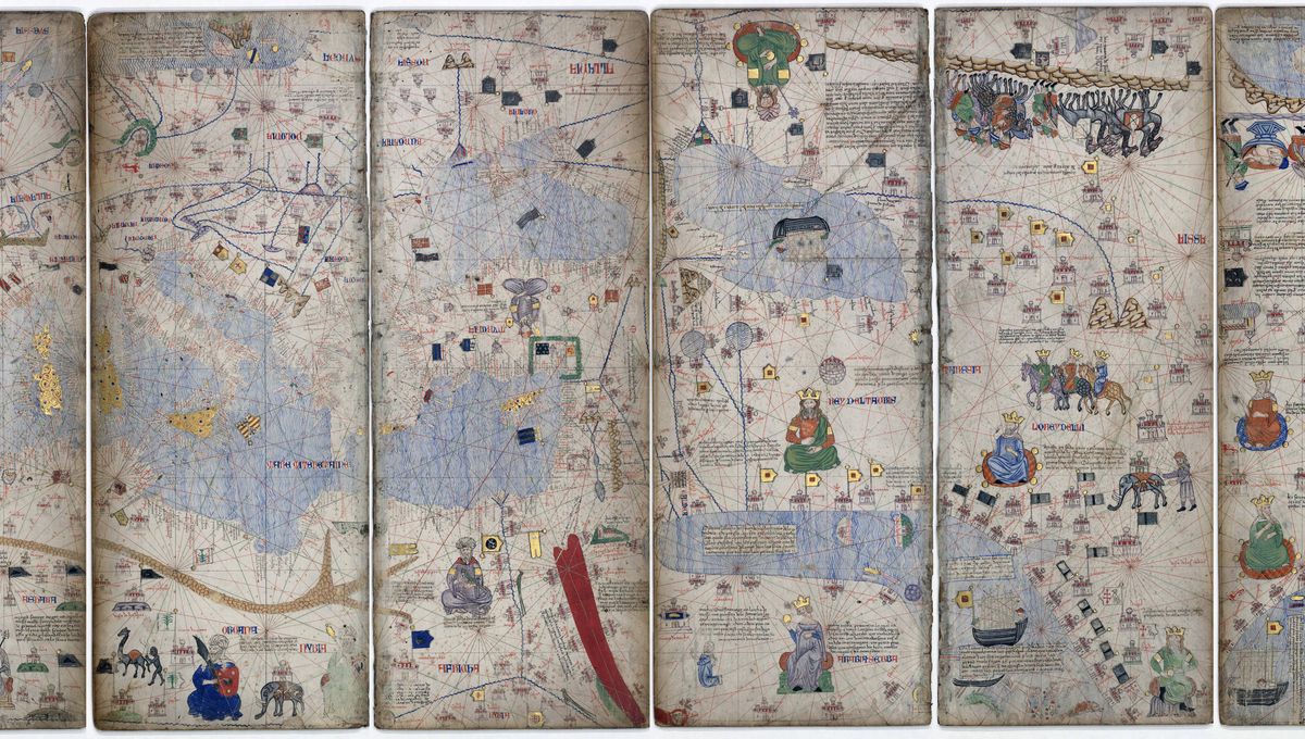
A fantastic example of a rich, detailed portolan map is the Catalan Atlas, created for Charles V of France by cartographers who produced it by compiling information from various sources. It is not completely clear who created the map, but it is often attributed to Abraham Cresques and his son Jahuda who were part of the influential Mallorcan cartographic school.
The Catalan Atlas is both a portolan map as well as a thematic representation of the world as it was imagined to be. Although it is filled with details of real places, it is also contains many fantastical features. As mentioned above, this was the trouble with compiling maps from various sources that included traveler tales and histories that were based in mythology. As such, monsters, dragons, sea beasties and hypothesized landmasses continued to appear on many maps long after its creation.
However, through a process of checking and refinement over the following centuries, maps became increasingly sophisticated and useful, even without the invention of planes or satellites. It just took a long long time.
Source Link: How Did People Make Maps Before Satellites Were Invented?