Hurricane Milton evolved from a Category 1 to Category 5 storm in under 12 hours – one of the most rapid intensifications ever observed in the Atlantic – to become the fifth strongest Atlantic hurricane in history, with wind speeds of up to 285 kilometers (180 miles) per hour.
The monstrous storm started to gather serious momentum on Monday, October 7, in Mexico’s Yucatán Peninsula before starting to embark across the Gulf of Mexico.
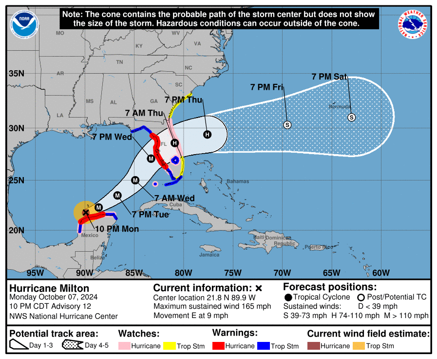
The hurricane – classified as Category 4 at time of writing – is set to grow in size through Tuesday on its journey, before meeting the west coast of Florida in the Tampa Bay region on the night of Wednesday, October 9, according to the National Weather Service (NWS).
Powerful wind won’t be the only problem when it hits. Dramatic pressure changes over the sea are set to cause an abnormal rise in sea levels that will flood the land, known as a storm surge. Some forecasters are predicting a 3.6-meter (12-foot) storm surge in Tampa Bay, leading to flooding of tens of thousands of homes, plus billions of dollars in damage.
Heavy rain on Tuesday through Wednesday night will also become a serious peril, causing flash flooding as well as major river flooding.

The forecasted path of Hurricane Milton as it moves towards Florida, as of October 8.
Image credit: NOAA/NWS
Needless to say, it’s a deeply worrying situation and authorities in the US are preparing for the worst.
“This is an extremely life-threatening situation and residents in those areas should follow advice given by local officials and evacuate immediately if told to do so,” the NWS added.
Tampa Mayor Jane Castor (D-FL) has issued Executive Order 2024-5, declaring a state of emergency due to Hurricane Milton. She’s called on all residents in Tampa Bay to evacuate the area before the storm strikes Wednesday, including some mandatory excavation orders for people in Hillsborough County and those living in mobile homes.
“This is the real deal here with Milton,” Castor told a news conference.
“If you want to take on Mother Nature, she wins 100 percent of the time,” she added.
To make matters worse, Florida was among the states struck by Hurricane Helene a couple of weeks ago in late September. In the deadliest hurricane to hit the mainland US since Katrina in 2005, at least 227 people lost their lives and bodies are still being recovered.
Authorities are attempting to clear debris left behind by Helene ahead of Milton’s arrival to stop strewn objects from becoming dangerous projectiles.
Hurricanes have become more intense over the past decade, so much so that some scientists argue we should introduce a new category to better reflect their intensity: Category 6, defined as having wind speeds exceeding 309 kilometers (192 miles) per hour.
The trend of record-breaking hurricanes has a strong link to human-driven climate change. Warmer sea surface temperatures provide more energy for hurricanes, potentially leading to increased intensity and faster wind speeds. Simultaneously, climate change may slow down the movement of hurricanes as they drift across geographical regions. This allows the hurricane to lurk over one area for longer, thereby increasing the amount of damage it can inflict.
Source Link: Hurricane Milton Goes From Category 1 To 5 In Just 12 Hours: A Monstrous New Record