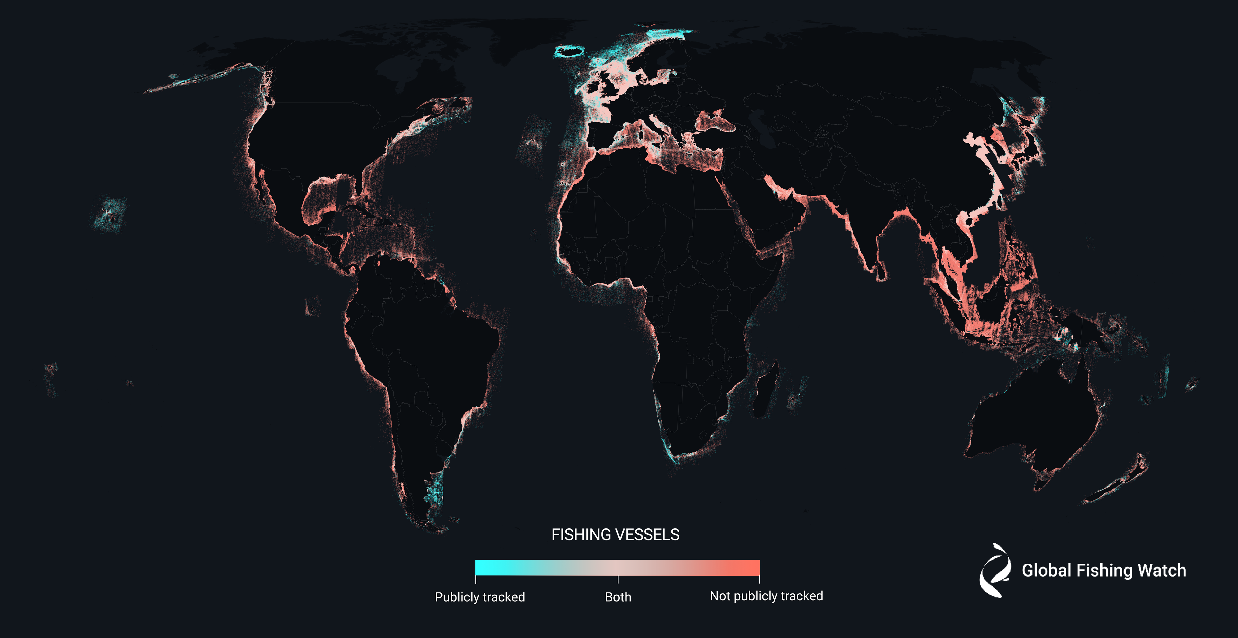
New analysis of the busiest areas of the world’s oceans has revealed that we know much less about what’s going on out there than you might think. The 2,000 terabytes of satellite data revealed that around three-quarters of industrial fishing vessels, and up to 30 percent of transport and energy vessels, are not publicly tracked, leaving us with a huge blind spot when it comes to human activity at sea.
The oceans are a vital resource for humanity, with over a billion people relying on them as a primary food source. Even now, over a century on from the peak of the Age of Sail, we still ship around 80 percent of all traded goods, and almost 30 percent of the world’s oil is produced offshore.
Given its importance to us, and the increasing calls for action to protect the planet’s waterways, you might think we’d have a firm handle on what all that shipping traffic is doing. According to a new study, however, a large number of vessels have been flying under the radar.
“A new industrial revolution has been emerging in our seas undetected – until now,” said co-lead author David Kroodsma, director of research and innovation at Global Fishing Watch, in a statement.
“On land, we have detailed maps of almost every road and building on the planet. In contrast, growth in our ocean has been largely hidden from public view. This study helps eliminate the blind spots and shed light on the breadth and intensity of human activity at sea.”
The study collated satellite imagery and GPS data from 2017-2021, using deep-learning models to classify seagoing objects with over 97 percent accuracy. The team mapped their findings in a series of incredible visualizations that offer what they call an “unprecedented view” of industrial activity in the ocean.

The majority of fishing vessels identified from the data are not being publicly tracked.
Image credit: © 2023 Global Fishing Watch
At any given time during the analysis, an average of 63,000 vessels could be detected. Almost half of these were fishing vessels, and the team discovered that 72 to 76 percent of these were not being monitored by any public tracking system. The majority of these, as you can see in the map above, operate around Africa and South Asia.
“With our freely available dataset and technology,” the authors write, “hotspots of potentially illegal activity can now be shown and industrial fishing vessels can be identified that are encroaching on artisanal fishing grounds or other countries’ [exclusive economic zones].”
Illegal fishing poses a threat to food stocks, and also runs the risk of unmanaged bycatch of threatened marine species. Being able to track fishing traffic with a greater degree of accuracy can only help to combat this problem.

About 25 percent of vessels involved in transport and energy are missing from the public trackers.
Image credit: © 2023 Global Fishing Watch
In addition to the “dark” fishing vessels, around a quarter of transport and energy vessels were found to be similarly untracked. Vessels are not required to broadcast their coordinates, so there’s no suggestion that the only reason why a vessel would go “dark” is because it is doing something illegal – but couple this with the fact that details of offshore infrastructure projects are often kept quiet, and you reach the situation in which we currently find ourselves.
That’s what Global Fishing Watch is looking to change by making their data publicly available.

The data focused on the areas of the planet where most industrial activity takes place, mapping important offshore projects like wind turbines.
Image credit: © 2023 Global Fishing Watch
“The footprint of the Anthropocene is no longer limited to terra firma,” said co-author Patrick Halpin, professor of marine geospatial ecology at Duke University. “Having a more complete view of ocean industrialization allows us to see new growth in offshore wind, aquaculture and mining that is rapidly being added to established industrial fishing, shipping and oil and gas activities.”
“This study marks the beginning of a new era in ocean management and transparency,” added Kroodsma.
The study is published in Nature.
Source Link: Incredible Maps Reveal Just How Many Untracked “Dark Vessels” Are In Our Oceans