• Email Us: [email protected]
  • Contact Us: +1 718 874 1545
  • Skip to main content
  • Skip to primary sidebar

Medical Market Report

  • Home
  • All Reports
  • About Us
  • Contact Us

Null Island: The Unreal Location That Inhabits The World’s Digital Maps

February 9, 2024 by Deborah Bloomfield

You have never been to Null Island. In fact, we don’t suppose many people actually have. However, speaking in terms of digital geospatial data points, it’s a place that’s been documented time and time again. 

Ok, enough with the riddles. Null Island is the jokey name given to the location at zero degrees latitude and zero degrees longitude. In other words, the intersection where Earth’s prime meridian meets the equator. This works out to be a point in the Gulf of Guinea, a portion of the eastern tropical Atlantic Ocean off the west coast of Africa.

Advertisement

Since its geographical coordinates are 0°N 0°E, it is frequently recorded as the geographic point of a location that’s been incorrectly inputted into a digital map. 

As explained by the US Library of Congress blog, the bug can occur for several reasons. Often, it’s simply a typo from the slip of a finger. While entering a place’s location into a digital dataset, misspelled street names or confusing building numbers can invalidate the address and result in its coordinates being automatically logged as null, which the computer records as 0°N 0°E.

In the event of most errors or incomplete entries, the dodgy data point will be assigned to the coordinates 0°N 0°E.

Advertisement

Null Island has become a simple way of identifying problematic or erroneous geocodes on maps. If you’re looking to clean up errors in a geographical database, a good place to start is by searching the coordinates 0°N 0°E where you’re likely to find many bug-laden entries.

Data analysts noticed this quirk and started to jokingly call it “Null Island,” utilizing it as a means to track down geocode errors. 

It’s not clear when the nickname arose, but the location of Null Island first appeared on Natural Earth, a public domain map maintained by volunteer geographers, before 2011.

In their words: “It is a fictional, 1-meter-square island located off Africa where the equator and prime meridian cross. Being centered at 0,0 (zero latitude, zero longitude) it is useful for flagging geocode failures which are routed to 0,0 by most mapping services.”

Advertisement

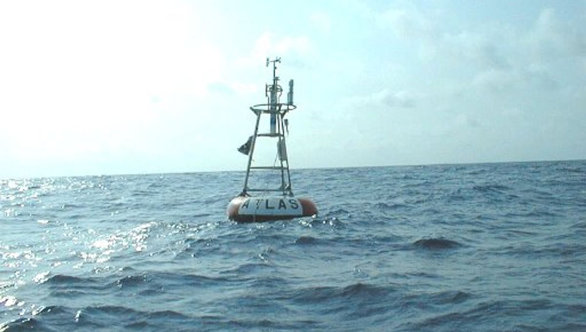
Of course, Null Island isn’t an actual landmass. However, if you literally sail out to the Gulf of Guinea towards the intersection between the world’s prime meridian and the equator, you will come across a large buoy. 

Known as Station 13010 – Soul, the weather-monitoring buoy is part of the Prediction and Research Moored Array in the Atlantic (PIRATA) system that keeps tabs on the tropical Atlantic Ocean. Together with 16 other buoys, the floating weather station measures things like wind speed, air temperature, and humidity to help inform weather forecasts and climate models.

In the real world, Null Island is just a lone buoy floating in the Atlantic. However, in the virtual world, it’s a hypothetical pin-point where misplaced data points lurk. 

Deborah Bloomfield
Deborah Bloomfield

Related posts:

  1. Soccer – FIFA backs down on threat to fine Premier clubs who play South American players
  2. U.S. House passes abortion rights bill, outlook poor in Senate
  3. UBS clients raise $650 million for biggest yet biotech impact fund
  4. We’ve Breached Six Of The Nine “Planetary Boundaries” For Sustaining Human Civilization

Source Link: Null Island: The Unreal Location That Inhabits The World's Digital Maps

Filed Under: News

Primary Sidebar

  • Earliest Evidence Of Making Fire Has Been Discovered, X-Rays Of 3I/ATLAS Reveal Signature Unseen In Other Interstellar Objects, And Much More This Week
  • Could This Weirdly Moving Comet Have Been The Real “Star Of Bethlehem”?
  • How Monogamous Are Humans Vs. Other Mammals? Somewhere Between Beavers And Meerkats, Apparently
  • A 4,900-Year-Old Tree Called Prometheus Was Once The World’s Oldest. Then, A Scientist Cut It Down
  • Descartes Thought The Pineal Gland Was “The Seat Of The Soul” – And Some People Still Do
  • Want To Know What The Last 2 Minutes Before Being Swallowed By A Volcanic Eruption Look Like? Now You Can
  • The Three Norths Are Moving On: A Once-In-A-Lifetime Alignment Shifts This Weekend
  • Spectacular Photo Captures Two Rare Atmospheric Phenomena At The Same Time
  • How America’s Aerospace Defense Came To Track Santa Claus For 70 Years
  • 3200 Phaethon: Parent Body Of Geminids Meteor Shower Is One Of The Strangest Objects We Know Of
  • Does Sleeping On A Problem Actually Help? Yes – It’s Science-Approved
  • Scientists Find A “Unique Group” Of Polar Bears Evolving To Survive The Modern World
  • Politics May Have Just Killed Our Chances To See A Tom Cruise Movie Actually Shot In Space
  • Why Is The Head On Beer Often White, When Beer Itself Isn’t?
  • Fabric Painted With Dye Made From Bacteria Could Protect Astronauts From Radiation On Moon
  • There Used To Be 27 Letters In The English Alphabet, Until One Mysteriously Vanished
  • Why You Need To Stop Chucking That “Liquid Gold” Down Your Kitchen Sink
  • Youngest Mammoth Fossils Ever Found Turn Out To Be Whales… 400 Kilometers From The Coast
  • The First Wheelchair User To Travel To Space Is About To Make History
  • “It Was Bigger Than A Killer Whale”: 66 Million-Year-Old Tooth Suggests Mosasaurs Were Hunting In Rivers, Not Just Seas
  • Business
  • Health
  • News
  • Science
  • Technology
  • +1 718 874 1545
  • +91 78878 22626
  • [email protected]
Office Address
Prudour Pvt. Ltd. 420 Lexington Avenue Suite 300 New York City, NY 10170.

Powered by Prudour Network

Copyrights © 2025 · Medical Market Report. All Rights Reserved.

Go to mobile version