• Email Us: [email protected]
  • Contact Us: +1 718 874 1545
  • Skip to main content
  • Skip to primary sidebar

Medical Market Report

  • Home
  • All Reports
  • About Us
  • Contact Us

Satellite Images Of Hurricane Ian Show This Monster Storm’s Ferocious Potential

September 28, 2022 by Deborah Bloomfield

Hurricane Ian is forecasted to hit the coast of Florida later today, Wednesday, September 28. Following fears of winds of over 250 kilometers per hour (155 miles per hour), the National Weather Service (NWS) has updated its storm warning to a strong category 4. They also warned of life-threatening storm surges, catastrophic floods due to intense rainfall, and possible tornados.

The center of Ian is expected to make landfall on Florida’s west coast just south of Tampa this afternoon, according to the NOAA’s latest public advisory. It is forecast to head northwards over central Florida tonight and Thursday morning, then emerge over the western Atlantic by late Thursday.

Advertisement

Over 2.5 million Florida residents were told to pack their belongings and evacuate their homes back when Ian threatened to make landfall as a category 3. Now the threat has been heightened to category 4, and some parts of the state are experiencing flooding and power outages already. 
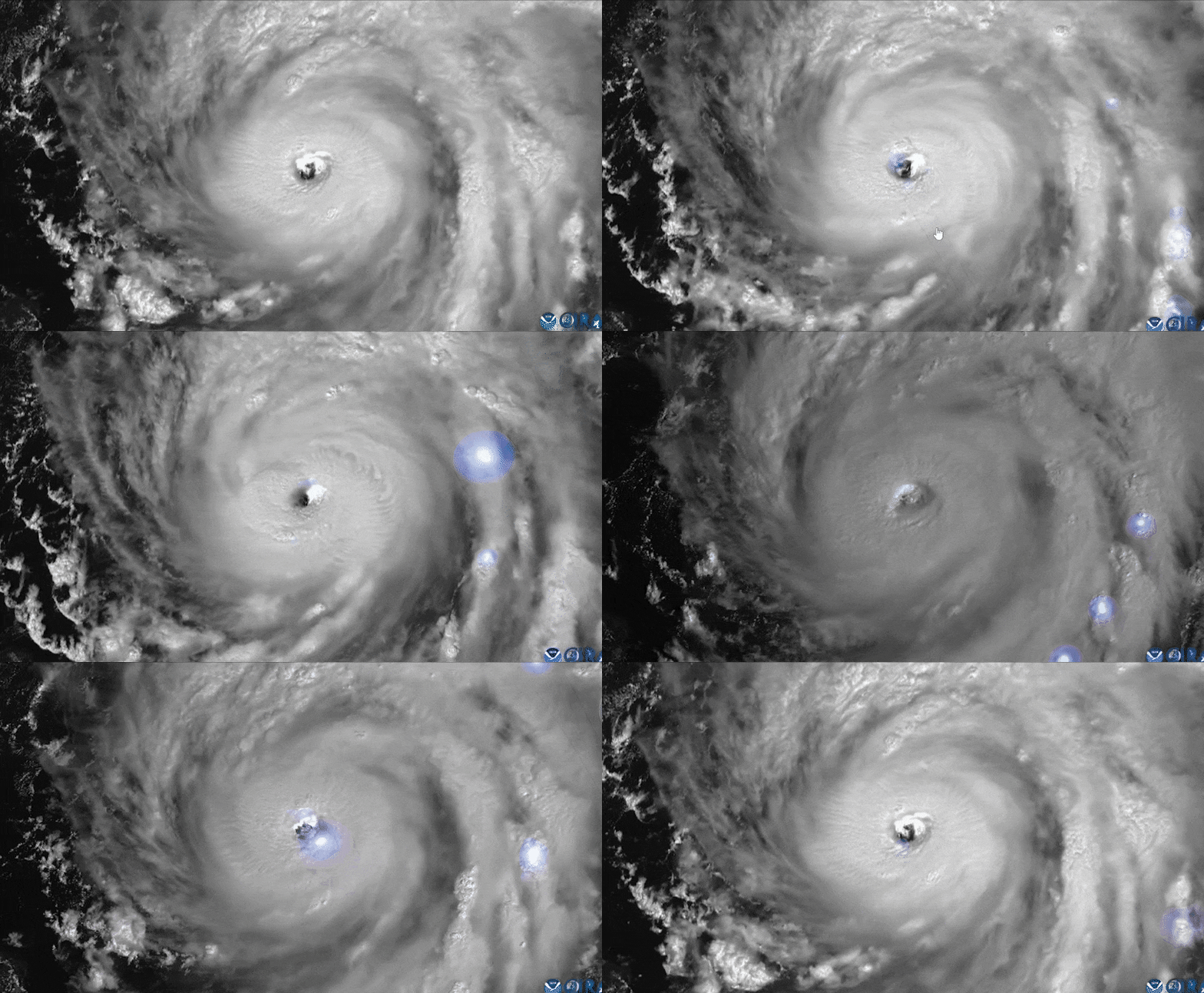
GIF of lighting bolts surrounding Hurricane Ian in the Gulf Of Mexico

GIF of lighting bolts surrounding Hurricane Ian in the Gulf Of Mexico. Image credit: NOAA/RAMMB/CIRA

“Life-threatening storm surge – one of many expected hazards with Hurricane #Ian – along the west coast of Florida has prompted evacuation orders for some communities. I urge those residents to heed directions from officials! Your safety is at the heart of these tough decisions,” NWS Director Ken Graham said in a tweet on Monday.

However, a handful of Florida residents have chosen to ignore the warnings and stay put. As NPR reports, this includes disabled people with mobility issues, those who can not afford to leave, and the brave few who have stayed to help others.

#Ian update from @NHC_Atlantic:

Ian now has a maximum sustained wind speed of 155mph — a Category 4 hurricane. Ian is expected to make landfall in southwestern Florida in the next few hours as a catastrophic hurricane. pic.twitter.com/CiI7AEeEmm

— National Weather Service (@NWS)

A looking at any of the satellite imagery will tell you that this is a serious storm. Hurricane Ian started in the Atlantic Ocean where it was first identified near the Caribbean Windward Islands. As it entered the Carribran Sea, it built up strength and carved northwards. 

Yesterday, it hit the west coast of Cuba, reportedly bringing sustained winds of 205 kilometers per hour (125 miles per hour), which wiped out huge parts of the country’s power grid. As it journeys up through the Gulf of Mexico, it only grew more powerful. 

Beyond the devastation set to come with Hurricane Ian, the storm has also disturbed the launch of the highly anticipated launch of the Artemis I mission to the Moon. Originally set for September 3, the launch has seen numerous setbacks over the past month and, last week, NASA called off its Artemis launch scheduled for September 27.

Advertisement

Buckle up and stay safe out there.

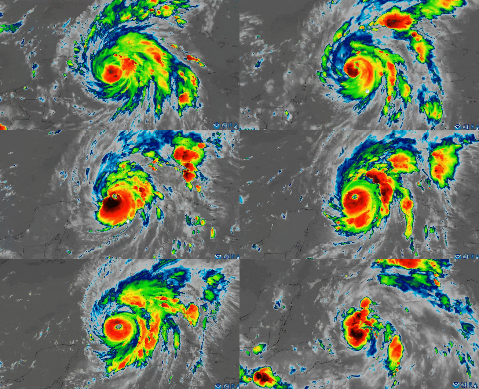
Infrared imaging shows Hurricane Ian's explosive development into a major hurricane as it edges over Cuba

Infrared imaging shows Hurricane Ian’s explosive development into a major hurricane as it edges over Cuba. Image credit: NOAA/RAMMB/CIRA

Deborah Bloomfield
Deborah Bloomfield

Related posts:

  1. China will maintain prudent monetary policy, says central bank official
  2. France says needs clarifications, explanations from U.S. after submarine deal
  3. MLB roundup: Salvador Perez breaks single-season HR mark for catchers
  4. Abu Dhabi’s Etihad seeks to hire up to 1,000 cabin crew

Source Link: Satellite Images Of Hurricane Ian Show This Monster Storm's Ferocious Potential

Filed Under: News

Primary Sidebar

  • Project Hail Mary Trailer First Look: What Would Happen If The Sun Got Darker?
  • Newly Discovered Cell Structure Might Hold Key To Understanding Devastating Genetic Disorders
  • What Is Kakeya’s Needle Problem, And Why Do We Want To Solve It?
  • “I Wasn’t Prepared For The Sheer Number Of Them”: Cave Of Mummified Never-Before-Seen Eyeless Invertebrates Amazes Scientists
  • Asteroid Day At 10: How The World Is More Prepared Than Ever To Face Celestial Threats
  • What Happened When A New Zealand Man Fell Butt-First Onto A Powerful Air Hose
  • Ancient DNA Confirms Women’s Unexpected Status In One Of The Oldest Known Neolithic Settlements
  • Earth’s Weather Satellites Catch Cloud Changes… On Venus
  • Scientists Find Common Factors In People Who Have “Out-Of-Body” Experiences
  • Shocking Photos Reveal Extent Of Overfishing’s Impact On “Shrinking” Cod
  • Direct Fusion Drive Could Take Us To Sedna During Its Closest Approach In 11,000 Years
  • Earth’s Energy Imbalance Is More Than Double What It Should Be – And We Don’t Know Why
  • We May Have Misjudged A Fundamental Fact About The Cambrian Explosion
  • The Shoebill Is A Bird So Bizarre That Some People Don’t Even Believe It’s Real
  • Colossal’s “Dire Wolves” Are Now 6 Months Old – And They’ve Doubled In Size
  • How To Fake A Fossil: Find Out More In Issue 36 Of CURIOUS – Out Now
  • Is It True Earth Used To Take 420 Days To Orbit The Sun?
  • One Of The Ocean’s “Most Valuable Habitats” Grows The Only Flowers Known To Bloom In Seawater
  • World’s Largest Digital Camera Snaps 2,104 New Asteroids In 10 Hours, Mice With 2 Dads Father Their Own Offspring, And Much More This Week
  • Simplest Explanation For “Anomalous” Signals Coming From Underneath Antarctica Ruled Out
  • Business
  • Health
  • News
  • Science
  • Technology
  • +1 718 874 1545
  • +91 78878 22626
  • [email protected]
Office Address
Prudour Pvt. Ltd. 420 Lexington Avenue Suite 300 New York City, NY 10170.

Powered by Prudour Network

Copyrights © 2025 · Medical Market Report. All Rights Reserved.

Go to mobile version