Spring may have technically sprung in the Northern Hemisphere, but the lingering impact of the collapsing polar vortex could ensure that chilly weather will stick around for a while longer across North America.
ADVERTISEMENT
April’s weather is set for a cold spell as an abrupt change in pressure patterns sweeps across North America. This atmospheric upheaval will unleash an unseasonable chill over parts of the eastern US and Canada, with the Midwest and Northeast bracing for an unexpected taste of winter and perhaps even some springtime snowfall.
This shift is driven by significant atmospheric pressure changes, triggered by the collapse of the polar vortex a couple of weeks ago, according to Severe Weather Europe. The breakdown in the polar vortex occurs as temperatures and pressure in the stratosphere surge rapidly, setting off a chain reaction that reshapes weather patterns below.
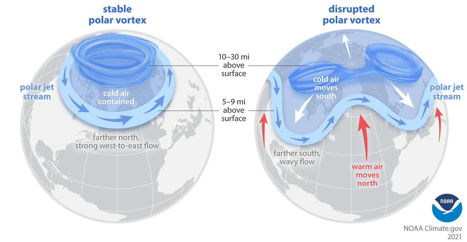
The polar vortex is a low-pressure system of cold air that swirls above both of Earth’s poles. Over the North Pole, the wind flows counterclockwise in the stratosphere around 16 to 50 kilometers (10 to 30 miles) high. It is closely related to the polar jet stream, a band of strong wind currents that forms at the boundary of the polar vortex. Together, these forces help to trap cold air around the poles.
However, the polar vortex can be disturbed or weakened due to numerous factors, allowing cold air to escape and move into lower latitudes.

The science behind the Polar Vortex and how it impacts weather in the Northern Hemisphere.
Image credit: NOAA
Severe Weather Europe reports that the latest disturbance in the polar vortex in mid-March initiated a series of large-scale pressure changes, setting the stage for cooler conditions in the eastern US and Canada while allowing warmer air to build in the west.
As per their forecast, the eastern half of North America will experience below-normal temperatures in mid-April, potentially reaching freezing in the Midwest and Northeast. This cold surge will also bring snowfall to the northern US and southeastern Canada, though drier air may limit total accumulation. Meanwhile, the western US and Great Plains will see above-average temperatures due to high-pressure influence.
ADVERTISEMENT
A similar prediction was published by Accuweather in early March, with their meteorologists forecasting a “rough and stormy pattern” for eastern North America in mid-March and early April.
“We are predicting a displacement of the polar vortex on the Europe and eastern Canada side of the polar. When the Polar Vortex is disrupted – whether stretched, displaced, or split – it can, but does not always, impact this polar jet stream,” Paul Pastelok, AccuWeather’s Lead Meteorologist, told The Independent in early March.
“The timing is uncertain for North America but could see a change in the pattern for late March into early April.”
Judging by the current tirade of ice storms battering eastern Canada, it looks like their prediction was spot on. However, it remains to be seen whether these intensely chilly conditions will hold throughout April.
Source Link: The Polar Vortex May Deliver An Ice-Cold April To The US And Canada