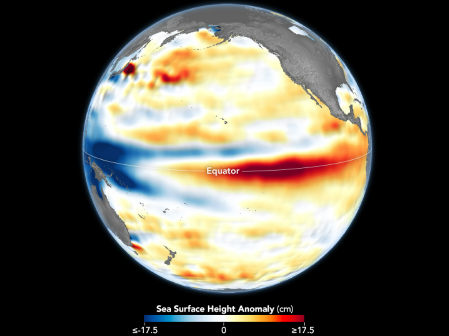
The rise and fall of the last El Niño phase has been beautifully captured in newly released data visualizations. Ocean conditions may look peaceful in the Pacific at the moment, but big change is brewing.
El Niño is a global climate phenomenon that has impacts on weather patterns worldwide, but it all starts with warm waters over the central and eastern tropical Pacific Ocean. The changing ocean influences atmospheric circulation, which can cause higher rainfall in some regions while sparking droughts in others. El Niño phases also typically create higher average global temperatures, raising the chances of record-breaking warm years.
The past year – 2023 to 2024 – has been marked by a particularly mighty El Niño phase that finally died out in May.
In newly released images, sea surface height anomalies are shown in the central and eastern Pacific Ocean on December 4, 2023, near the peak of El Niño, compared to July 1, 2024, during its current neutral phase.
Sea surface height anomalies are an interesting way to track temperature differences in the sea because they are directly influenced by thermal expansion; warmer water expands and results in higher sea surface levels. By analyzing the anomalies, scientists can identify areas where the ocean is warmer or cooler than average.
The data for the maps were gathered by the Sentinel-6 Michael Freilich satellite, named after the esteemed NASA oceanographer, and processed by NASA’s Jet Propulsion Laboratory (JPL).
“This was a sizable El Niño, but not the biggest we’ve seen in the last 30 years,” Josh Willis, an oceanographer at NASA’s JPL, said in a statement.
Water was warmer than usual around the Equatorial Pacific in December 2023, close to when El Niño peaked.
Image credit: NASA Earth Observatory/Lauren Dauphin, using modified Copernicus Sentinel data, processed by ESA and further processed by Josh Willis, Severin Fournier, and Kevin Marlis/NASA/JPL-Caltech.
Now the last El Niño is dead, the equatorial Pacific is currently in a neutral phase and meteorologists at the National Oceanic and Atmospheric Administration’s Climate Prediction Center are expecting it will remain this way until at least August 2024.
Following the neutral period, there’s a strong chance La Niña will return. If El Niño is known as the “warm phase”, La Niña is the “cool phase” characterized by unusually cool ocean temperatures in the Equatorial Pacific. If it were to appear on similar maps as seen above, you’d expect to see a strip of blue around the equator in the East Pacific, denoting its chilly waters.
La Niña can lead to drier weather in the southern US, but notably wetter and colder weather in the Pacific Northwest and Canada. We tend to see warmer winter temperatures in the South during La Niña and cooler temperatures than normal in the North. It also fosters less severe hurricane seasons in the Pacific but fuels a more severe hurricane season over the Atlantic. We can also expect to see drier conditions in East Africa, as well as wetter weather in Australia and parts of Southeast Asia.
Globally, La Niña phases are generally cooler than others. While we might expect global temperatures to be slightly lower in the La Niña year ahead (at least compared to the recent record-smashing years), the long-term trend of warming temperatures as a result of human-generated carbon emissions is likely to ensure that we continue to see climbing temperatures around the world.
Source Link: The Rise And Fall Of El Niño Shown In Beautiful Maps By NASA
