It looks like it’s all over for the exceptional “triple-dip” La Niña weather event that cooled the Pacific Ocean and shaped the Earth’s weather for the past three years. However, scientists have already warned that an El Niño warming phase could be brewing. If true, then it could have some worrying implications for the warming of the planet.
On March 14, Australia’s Bureau of Meteorology announced that international climate models suggest the El Niño–Southern Oscillation is currently neutral following three years of La Niña conditions.
They added that they are already shifting straight to a so-called El Niño WATCH, as the odds of El Niño conditions emerging later in 2023 is over 50 percent.
If this prediction is on point, then El Niño has the potential to drive heat waves and push the global temperature even higher than in the past few years.
A strong El Niño can add up to 0.2°C (0.36°F) to the average temperature of the Earth. Since the planet has already warmed by around 1.2°C above pre-industrial levels, El Niño could raise the global average temperature over the much-hyped 1.5°C (2.7°F) threshold, which would mark a depressing milestone in the planet’s climate crisis.
As ever though, nothing is certain.
“The 3-year La Niña event has come to an end, but it’s not clear yet what comes next,” Dr Nandini Ramesh, Senior Research Scientist in Natural Hazards at CSIRO and the University of Sydney, said in a statement.
“Predicting how the Pacific Ocean and atmosphere will evolve from this time of year (March-May) is notoriously difficult […] So while most forecast models now predict an upcoming El Niño, I wouldn’t place any bets just yet,” she added.
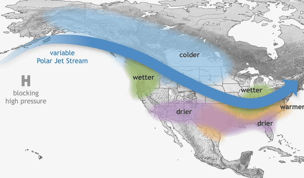
This is how La Niña affects weather in North America. Image credit: NOAA
What is La Niña and the El Niño-Southern Oscillation?
The El Niño-Southern Oscillation is a complex cycle that describes how a pattern of temperature fluctuations in the Pacific Ocean has a global impact – from wind, temperature, and rainfall patterns to the intensity of hurricane seasons, and even the distribution of fish in the seas.
The cycle flips between El Niño and La Niña phases every few years, with neutral phases in between.
During El Niño, ocean water becomes warm around the central Pacific, resulting in a knock-on effect across the world. The warmer waters cause the Pacific jet stream to move south and extend, causing drier and warmer weather to hit northern parts of the US and Canada, but wetter weather in southern states.
Over in the Atlantic Ocean, El Niño actually weakens hurricane seasons, while strengthening hurricane activity in the central and eastern Pacific basins.
La Niña is the other side of the coin, and describes the Pacific’s cooling phase, which also has a far-reaching impact on the world’s climate.
So, What’s A “Triple-Dip” La Niña?
The past three years have been particularly unusual, as the world has been in the midst of a rare “triple-dip” La Niña that’s persisted since around September 2020.
One of the most significant impacts of this “triple-dip” La Niña has been seen in the Atlantic coast of the Americas, which saw a record-breaking hurricane season in 2020 and the third most active hurricane season in 2021.
The wild hurricane seasons have a link to La Niña, as it removes the conditions that suppress storm formation seen in El Niño, and hurricanes are encouraged to form.
Man kayaking along the flooded streets of Brisbane, Australia – February 28, 2022. Image credit: Alex Cimbal/Shutterstock.com
On the other side of the world, the lingering La Niña impacted Australia, which was hit by freakishly wet weather in 2022 and subsequent flooding.
“The Bureau’s declaration that La Niña has ended heralds the official end of the ‘big wet’, a rare triple-dip La Niña that was only the fourth since 1900 and the first in 22 years,” explained Dr Tom Mortlock, a Senior Analyst at Aon and Adjunct Fellow at the UNSW Climate Change Research Centre.
“This period saw Sydney’s wettest year on record, and led to what turned out to be Australia’s largest insured loss event ever in the February – March NSW and QLD floods. Current insurance industry reported losses for this event sit at AUD 5.76 bn, which now surpass the 1999 Sydney hailstorm (AUD 5.57 bn) as Australia’s largest,” he added.
Source Link: The "Triple-Dip” La Niña Is Finally Over, But Now El Niño Looms
