A cave shelter near Paris already known to host unique Palaeolithic art also appears to hold a three-dimensional map or model of the area around it, two archaeologists have claimed. If true, this would likely make it the oldest known representation of its kind, and certainly unmatched in scale from the era.
The caves of southern France are famous for the breathtaking representation of animals and hunting painted on their walls, along with more abstract images. Further north, despite more than 2,000 engravings having been found in shelters in the Fontainebleau sandstones, figurative art has only been reported from three. One of these, known as La Ségognole 3, is one of the most important cave art sites in the world, unless the authors of a new paper have made a giant mistake..
La Ségognole 3 contains two engravings of horses, one badly eroded. The location makes these unusual, but further south they might not attract much attention. However, between these horses lie three slots that have been shaped to enhance their resemblance to a female pelvis and thighs. More remarkably, Dr Médard Thiry of the French Center of Geosciences and colleagues reported in 2020, the surrounding rocks have been modified so that water drains naturally into the stone “vulva”, adding realism after every rain.
That paper, while peer-reviewed, hasn’t attracted much attention; surprising given the combination of unique art and sex, with all citations in the four years since being by some of the original authors. However, Thiry and co-authors have continued to research what they consider a remarkable find.
Among other things, they claim these three caves (one now destroyed by quarrying) were all marked with standing stones at their entrances. These stones were taken as natural, being formed from the dominant local stone, but Thiry and colleagues claim they show unambiguous signs of human placement.

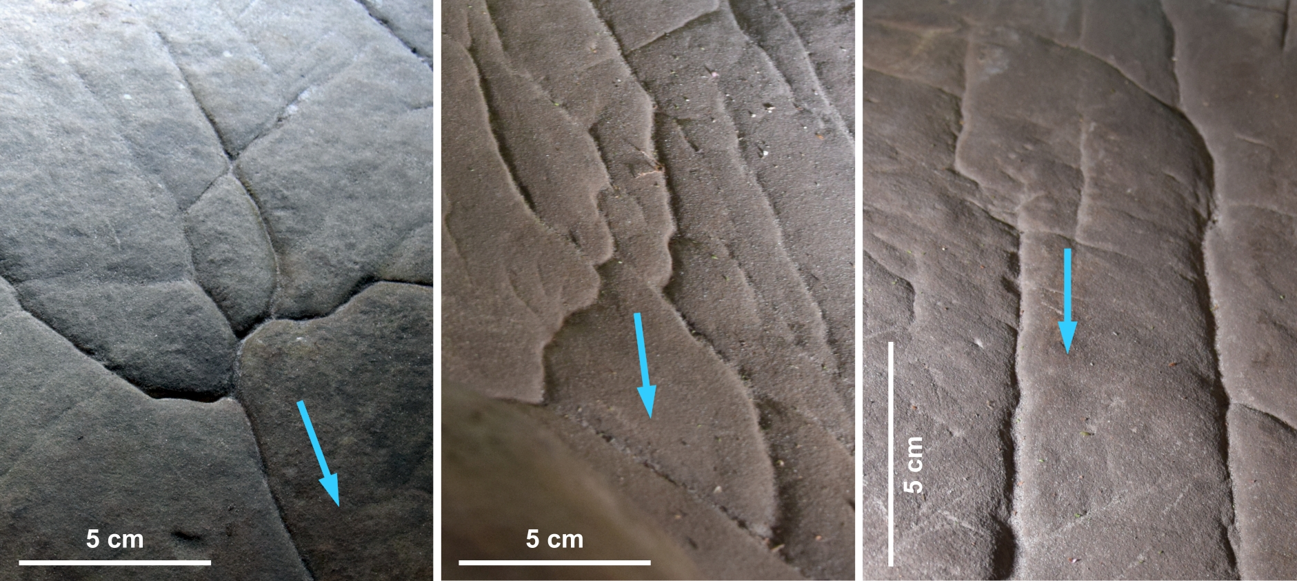
The flow of water through the cave marked with blue arrows.
Image courtesy of Dr Anthony Milnes
Thiry’s latest update, published with co-author Dr Anthony Milnes of the University of Adelaide, proposes something even more remarkable than the hydrological enhancement of Palaeolithic sexual representation. Next to the pelvis, Thiry and Milnes identify what they say are other modifications made to the floor of the shelter, which shape the way water flows over it. Some of this work enhances natural features in the rock, but other examples cut against the grain to create gutters and grooves where none were there before.
This suggests the makers had a deliberate design in mind, rather than just being bored cave people in a wet spell deciding to emphasize what they could already see.

The grooves on the cave floor may look alike, but some show signs of being deliberately shaped to direct the flow of water.
Image courtesy of Dr Anthony Milnes
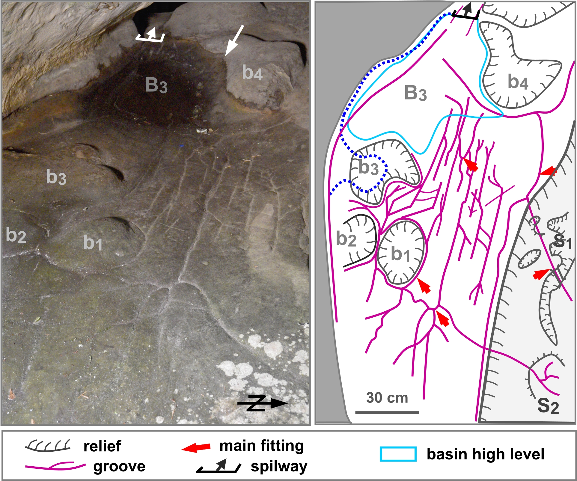
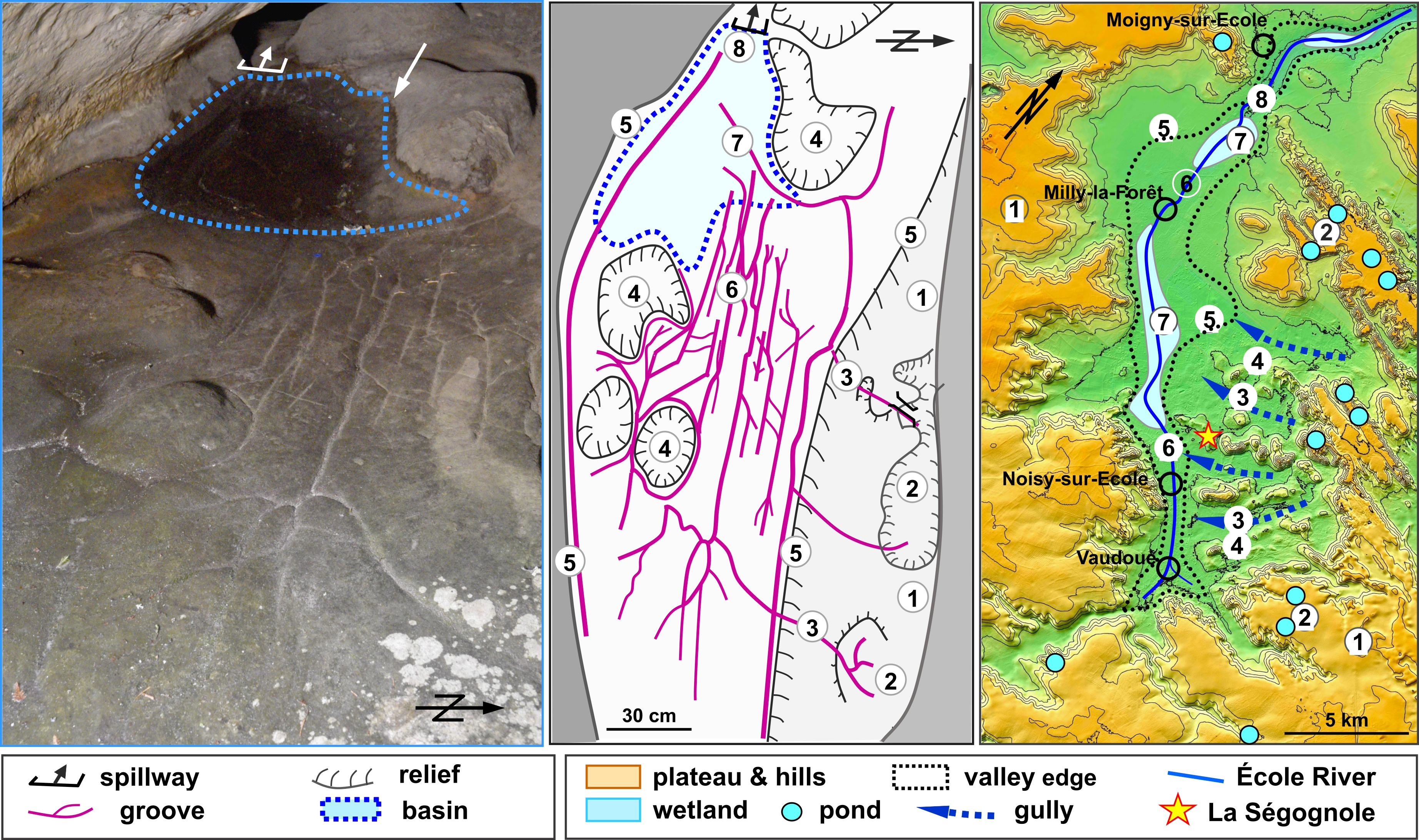
When an upper basin fills after rain, some flows to the stone vulva, but the rest follows depressions in the floor like a tiny, winding river. Thiry and Milnes note eight places where the shaping of the floor has made it resemble aspects of the upper River Ecole valley, overlooked by the hill that contains La Ségognole. Since the Middle Ages, some of the valley’s wetlands have been drained, and rivers turned to canals, so the similarity may have been stronger in the late Ice Age. Even today, the pair argue the match is too close to be a coincidence.
“[T]he engraved gallery floor in Ségognole 3 appears to be a representation of the spatial relationship of landscape features and may be considered a miniature of the natural feature and their relationships in the adjourning landscape,” Thiry and Milnes write. If so, the stone floor has been carved into something between a relief map and a model.
The similarity becomes clear when rain seeps through fractures in the overhanging rock and cascades over the top, the authors claim, with a series of basins and channels looking like river deltas and wetlands.
This would all have taken considerable work to achieve. For example, marks indicate some of the basins were made by removing large flakes of sandstone. “Given their size, the flakes must have been detached with a heavy hammerstone,” Thiry and Milnes write. Other work lowered the spillway from one basin, ensuring that it spilled more often, while the bottom of another has been carved flat with sharp junctions to the walls.

The basins that store rainwater and the networks through which it drains.
Image courtesy of Dr Anthony Milnes
Given what the makers had to work with, the floor could never be a perfect representation of the valley. Thiry and Milnes think certain sandstone bulges are thought to represent foothills on the right bank or the river, but on the cave floor, they are sited to the left.
Nevertheless, the authors say the overall accuracy “reveals a remarkable capacity for abstract thinking in those who drew it and in those for whom it was intended.”
They must have had some community and belief system that enabled these things to be developed, but we just don’t know what was going on in their minds.
Dr Anthony Milnes
Enough maps from the Neolithic and Bronze Ages survive to suggest they were widespread then, but only a few disputed examples have been found from the Palaeolithic. For example, some mammoth tusks have been engraved with geometric patterns and diagonal lines that may represent mountains and valleys. The clearer examples are probably younger than the Ségognole 3 carvings, but more importantly, the shelter’s floor is on a very different scale from a piece of ivory.
The closest parallel Thiry and Milnes are aware of is Abauntz cave, which has a slab engraved with markings that may represent nearby mountains, rivers, and the animals that lived there. The Abauntz work is thought to be around 13,600 years old.
Milnes told IFLScience: “If you look at the whole program of work, the adaptations made to the appearance of the cave indicate all the work was from the same period of time.” Although we currently lack a method to date that, the horses resemble the style of Lascaux, which is thought to have been painted 17-22,000 years ago. Consequently, Thiry and Milnes think the horses, and therefore everything else, date from the same period.

A comparison of the relevant area of the cave floor with carved grooves marked and a map of the Ecole Valley. Sites the authors believe match are numbered.
Image courtesy of Dr Anthony Milnes
If the cave floor does represent the valley, it could have been done to assist in the planning of hunts, telling of stories, or the conduct of rituals. Thiry and Milnes also raise the possibility the carving was part of a dialogue between the inhabitants and the landscape, a way of making the valley live. “Clearly these locations were very important [to those who reshaped the cave].” Milnes told IFLScience, “They must have had some community and belief system that enabled these things to be developed, but we just don’t know what was going on in their minds.”
Such a large map from the Ice Age would be a discovery of global significance. The ability to redirect water is one of the hallmarks of agriculture, so two demonstrations side by side from thousands of years before is particularly astonishing. It’s even more unexpected for it to be located away from the regions associated with the era’s most advanced art, in an area that would have been particularly forbidding during the Ice Age.
The lack of response to Thiry’s previous papers might suggest most archaeologists are unconvinced. However, Milnes, whose background is in geomorphology rather than archaeology said: “I suspect this is because they were confronted with new ideas and have taken some time to work out what this might be.” He says he has experienced no pushback from experts, who might be skeptical of the deliberate nature or timing of the cave’s reshaping. However, he acknowledges the team can’t explain why the work was so much more advanced than anything else known from the time, nor in a location lacking similar examples.
The study is published in the Oxford Journal of Archaeology.
[H/T]: ScienceAlert
Source Link: The World’s Oldest 3D Map May Accompany Sexually Suggestive Cave Art