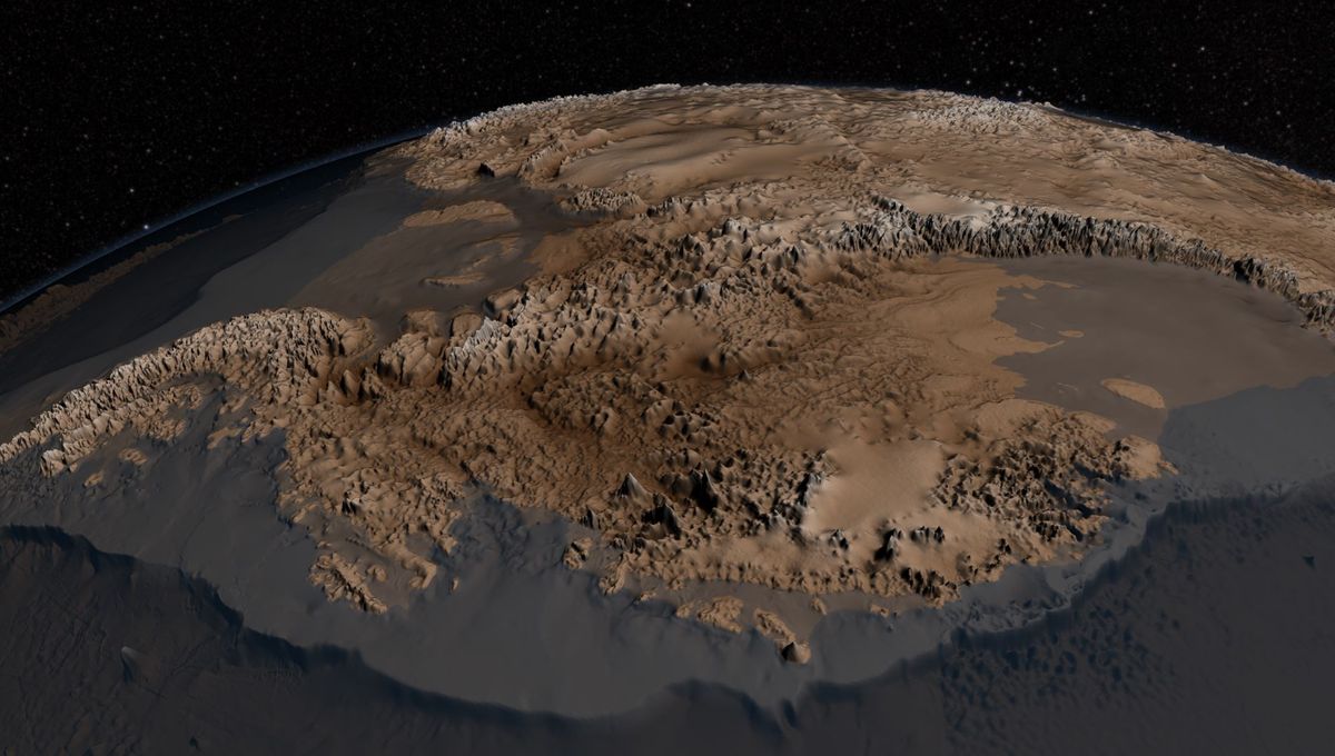
Ice covers around 98 percent of the Antarctic continent, shielding the vast majority of its land mass from sight. However, thanks to some incredible imaging techniques, we’re able to gain a deeper understanding of what the continent of Antarctica would look like without ice.
The Bedmap2 was created back in 2013 using vast amounts of data on surface elevation, ice thickness, and bedrock topography collected by NASA and the British Antarctic Survey from satellites, aircraft, and surface-based surveys.
As the map shows, the naked land beneath the Antarctic ice sheet is a rugged land, covered in mountain ranges, gorges, and jagged terrain. Remarkably, one part of the bed found under the Byrd Glacier in Victoria Land is 2,870 meters (9,416 feet) below sea level, making it the lowest point on any of the Earth’s continental plates.
“Bedmap shows, with unprecedented detail, the bedrock beneath the ice sheets of Antarctica. Before we had a regional overview of the topography, but this new map, with its much higher resolution, shows the landscape itself; a complex landscape of mountains, hills, and rolling plains, dissected by valleys, troughs, and deep gorges,” Peter Fretwell, from the British Antarctic Survey, said in a statement in 2013.
One of the important tools used to scoop this data was an ice-penetrating radar instrument known as the Multichannel Coherent Radar Depth Sounder that’s able to determine ice thickness and subglacial topography.
Understanding the shape of this subglacial world is important as it impacts how ice is distributed and influences how it will melt in the face of rising oceans and air temperatures linked to climate change.
“Ice sheets grow because of snow, and like honey poured on a plate, spread outward and thin due to their own weight,” Sophie Nowicki, an ice sheet scientist at NASA’s Goddard Space Flight Center in Greenbelt, explained in another statement.
“The shape of the bed is the most important unknown, and affect how ice can flow,” she added. “You can influence how honey spreads on your plate, by simply varying how you hold your plate.”
The Bedmap2 data reveal that Antarctica harbors 27 million cubic kilometers (6.4 million cubic miles) of frozen water that, if melted, would result in around 58 meters (190 feet) of sea-level rise.
While the entire Antarctic ice sheet is not predicted to totally melt under current climate projections, it’s painfully clear that it is slowly thawing at a shocking rate. The latest estimates suggest the world’s oceans are now rising by 4 millimeters (0.16 inches) each year as a result of thawing ice sheets in Antarctica and Greenland. This, they believe, is almost exactly the “worst-case scenario” put forward in the United Nations Intergovernmental Panel on Climate Change (IPCC).
To gain a better understanding of ice thickness and the world beneath Antarctica, scientists are now building the next-generation map, Bedmap3.
Source Link: This Is What Antarctica Looks Like Naked Beneath All The Ice