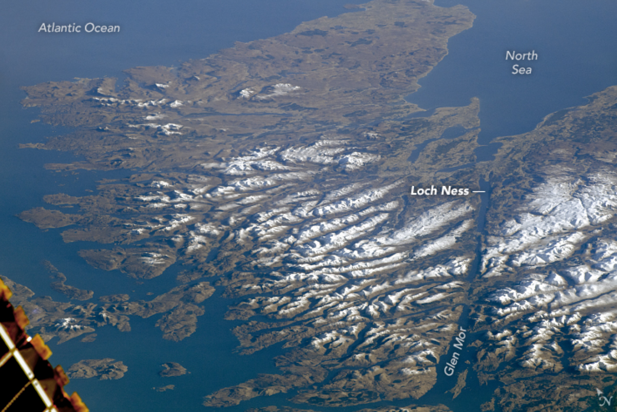
Take a look at any satellite image of Scotland and you’ll hopefully see a giant scar running diagonally through its upper reaches from northeast to southwest. It’s a colossal reminder that very few things on planet Earth ever remain unchanged – including its seemingly sturdy landmasses.
This gigantic geological feature is known as the Great Glen Fault. Scientifically speaking, it’s a strike-slip fault, a fracture created by two giant blocks of Earth’s crust that have slid horizontally past one another.
It emerged towards the end of the Caledonian Orogeny (around 430 to 390 million years ago), a massive mountain-building event that unfolded over 150 million years due to ancient continents — Laurentia, Baltica, and Avalonia — slowly colliding with each other. As these landmasses collided, their edges crumbled and folded into mountain ranges and jagged valleys.
The fault neatly lines up with the Great Glen, a 100-kilometer (62-mile) valley that runs from Inverness in the northeast to Fort William, leaving behind a series of dramatic lochs, including Loch Ness (of long-necked monster fame) and the superbly named Loch Lochy.
An astronaut on the ISS captured this image of the Scottish Highlands showing the fault zone marked by numerous elongated lakes (aka lochs).
Not only do these geological happenings define the geography of Scotland, but they’ve also had a major impact on the human history of the region.
Above the Great Glen Fault, the country is characterized by harsh conditions and challenging terrain. These factors contributed to the dominance of the Scottish clans, the network of extended family groups and communities that thrived in these isolated, rugged, and difficult-to-control pockets of the Scottish Highlands.
The Great Glen, acting as a natural divide between the Western Highlands and the rest of Britain, became a crucial strategic crossroads during the bloody Jacobite uprisings of the 17th and 18th centuries. As clans and armies vied for control, this valley region was a key battleground in the fight to overthrow the ruling House of Hanover and restore the House of Stuart to the British throne.
The legacy of this period can be seen in the number of fortresses built along the Great Glen, including Fort William in the south, Fort Augustus in the middle, and Fort George in the northeast. It’s also home to much older (and incredibly beautiful) castles, highlighting that this craggy boundary has long been the site of clashing clans and vying powers.
Today, things are much quieter, militarily and geologically. As of the 20th century, the fault was still considered to be active, meaning it was capable of slipping. As a result of the creeping geological movement, earthquakes do occasionally rumble through the Highlands today, although they tend to be pretty minor.
Source Link: What Is This Giant Line That Slices Through Scotland?
