Australia is the fastest-moving continent on Earth, resting on top of a tectonic plate that’s drifting at about 7 centimeters (just under 3 inches) each year – that’s somewhere between the rate at which your hair and fingernails grow.
By comparison, Earth’s land masses move at an average rate of about 1.5 centimeters (0.6 inches) a year, according to NOAA. By comparison, Australia is ahead of the competition as it embarks on its northward drift.
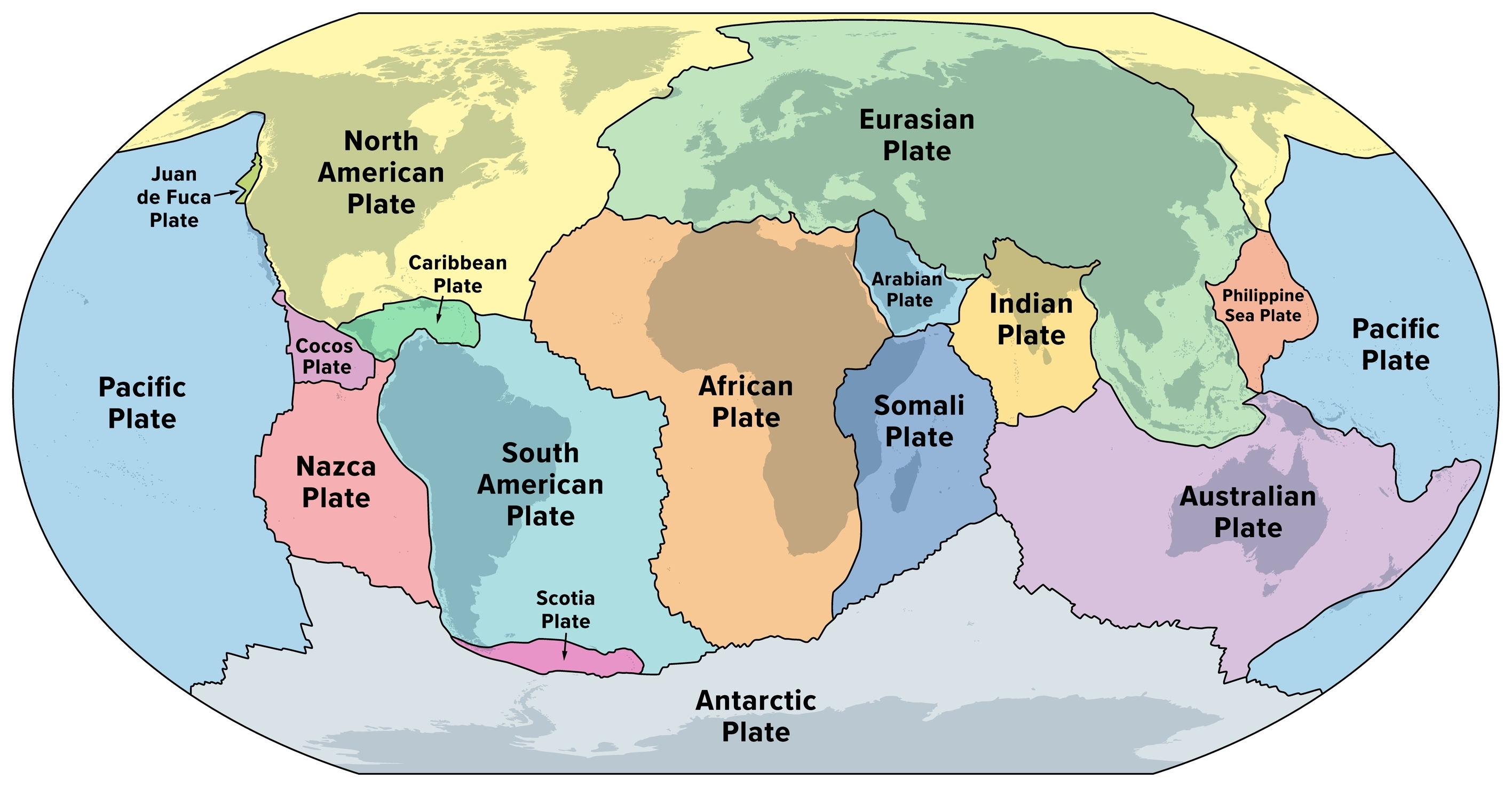
Technically speaking, we’re talking about the Indo-Australian plate, a tectonic plate that includes mainland Australia and the island of Tasmania, plus portions of New Guinea, New Zealand, and the Indian Ocean basin.
Eventually (let’s say, a few tens of millions of years from now), it’s possible that the Indo-Australian plate could smash into the bottom of the Eurasia plate around Southeast Asia and China, forming a new continental array that some have dubbed “Austrasia”.
This move isn’t without historical precedent. Until 200 million years ago, Australia was connected to Gondwana, a massive supercontinent that occupied most of the Southern Hemisphere. Under this setup, the African Plate, Antarctic Plate, Indo-Australian Plate, and South American Plate were all smooshed together. Meanwhile, Laurasia – including most of today’s Europe, Asia, and North America – all sat together in the Northern Hemisphere.
Map showing the principal tectonic plates of the Earth.
Image credit: Peter Hermes Furian/Shutterstock.com
It’s important to remember that Earth’s continents are constantly in a state of (veeery slow) flux. We don’t feel it in our everyday lives while wandering around Earth, but the planet’s surface is not as solid as it seems. Tectonic plates are constantly moving, some crashing into each other, others drifting apart. Rather than a rock-solid sphere, another way to imagine Earth is like a cracked road on a slow-moving conveyor belt. Some cracks widen, others get squeezed, and the entire surface is in motion; it’s just at a pace too slow to see.
As sluggish as it may be by human standards, it’s fast enough to cause confusion for our technology. Geolocation tools – like the US’s Global Positioning System (GPS), Russia’s GLONASS, the European Union’s Galileo, and China’s BeiDou – use satellites to determine locations in relation to known reference points. However, these satellites operate based on fixed coordinate systems, while the landmass itself is slowly shifting. Over time, this movement creates a mismatch between where maps think locations are and where they actually are.
Until 2017, Australia used coordinates from 1994. Over 23 years, it became out of sync with the tectonic plate by 1.6 meters (5.2 feet), forcing them to update the system. In effect, Australia officially moved 1.8 meters (5.9 feet) northeast.
Source Link: Which Of Earth's Continents Is Moving The Fastest? And Where Is It Going?
