When you imagine a map of the world, it’s probably a very particular image that comes to mind; There’s North America, Norway, and the North Pole at the top; and South America, South Africa, Australia (from the Latin australis, meaning South), and the South Pole at the bottom. You know – just how every map you’ve ever seen has probably laid it out.
ADVERTISEMENT
That image of the world is certainly not wrong – but it’s not exactly right, either. The fact is that putting North at the top of the map is a completely arbitrary choice – and not necessarily the most obvious one, either. So why do we do it at all?
Before North was up
North may seem the natural choice for the top spot these days, but that wasn’t always the case. In fact, humanity’s first instinct seems to have been the exact opposite: in the Turin papyrus – pretty much the oldest surviving topographic map in existence, especially if you exclude the more crude and abstract sketches that make up most of the “maps” predating it – South is at the top, and North points down.
It makes sense if you’re an ancient Egyptian. The South is where the Nile comes from – it flows North towards the Mediterranean – and since for the ancient Egyptians, nothing was more important to their lives and livelihoods than their river, of course that would take pride of place at the top.
In other cultures, the world was rotated 90 degrees again – but very rarely would it flip to what we consider normal today. “North was rarely put at the top for the simple fact that north is where darkness comes from,” Jerry Brotton, a map historian from Queen Mary University, London, and author of A History of the World in Twelve Maps, told the BBC in 2016. “West is also very unlikely to be put at the top because west is where the sun disappears.”
That left South, as the Egyptians opted for – or East, where the sun came from. In cultures that weren’t so dependent on the life-giving Nile, that likely made East the most important direction, and therefore the “up” on any physical or perceptual maps.
“We get clues that East was on top, even though no map survived to prove it,” explained Map Men Jay Foreman and Mark Cooper-Jones in a 2023 video for their Map Men series. “In India, the Sanskrit word ‘dakshina’ means both ‘South’ as well as ‘to the right’ – and if South was to the right, then East must have been at the top.”
ADVERTISEMENT
The same is true in Celtic languages like Welsh, Cornish, and Irish; in fact, it’s even true in English, in a way – the very fact that we orient ourselves is a reference to finding East, because that was the prime direction in times past. Indeed, Medieval European maps not only put East at the top, but they would often have Jerusalem right in the center too, making their overall appearance very different from what we’re used to today.
While Medieval Christians looked to the East, however, Islamic scholars had reverted back to putting South at the top – and for a very similar reason, actually: it was so that their maps had their holiest city at the top. For Muslims, that city was not Jerusalem, but Mecca – and since most early Muslim cultures were North of Mecca, that meant South had to point upwards.
Basically – with only very few exceptions, such as Ancient China or Babylon – North was almost never “up” in the ancient or even medieval world. Even Columbus, when he made his infamous journey across the Atlantic, was working with a mental picture one quarter-turn around from ours: “When [he] describes the world it is in accordance with east being at the top,” Brotton told the BBC. “Columbus says he is going towards paradise, so his mentality is from a medieval mappa mundi.”
Why did North become up?
At some point, evidently, the world seems to have got together and agreed that North should be up – but when, and why, did such a sea change come about?
ADVERTISEMENT
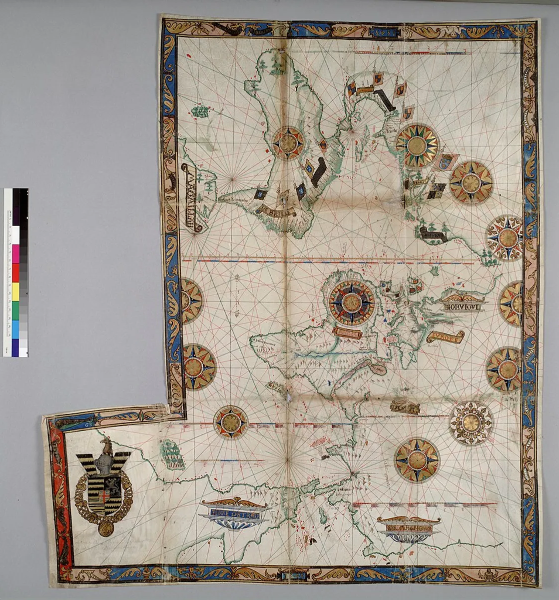
Well, we’re not entirely sure. A popular idea is that it happened during the European Age of Exploration, when navigation by the North Star became an important skill. But the chronology for that doesn’t quite ring true, some experts believe: after all, the position and utility of Polaris were known at least as far back as the first century BCE, while East-oriented maps were still being created well into the 16th century, some 100-150 years after Columbus and Magellan.

A world map by Guillaume Brouscon, an example of a Dieppe map, from 1543. Note that East is at the top (also most of South America is missing, but we’ll ignore that for now.)
Perhaps, then, it was a different navigational aid that was to blame: the compass, which harnesses the Earth’s natural magnetic field to indicate North. But again, this doesn’t hold up: compasses date back to the 10th century for navigation, and far earlier than that for mystical uses – far before the world settled on North as the upright direction on a map. And in any case, there’s no particular reason compass use would prompt the wholesale adoption of North at the top – the instruments also point South, after all, and there was more history of that direction taking precedence than the opposite. In China, the country with the longest history of compass use, we can even see this quibble play out for real: the navigational aids are called 指南针, which translates to “needle that points South”.
In the end, it may have been sheer luck that won North its place at the top. Mercator’s world map from 1569 seems to have been the map that changed everything; it revolutionized cartography in myriad ways, being the first map to take into account the curvature of the Earth and present rhumb lines – that is, sailing courses of constant bearing – as straight lines.
Mercator oriented his map with North at the top, but exactly why he made that choice is a mystery. He certainly didn’t think the poles were very important: “Mercator projected the poles to infinity. He says in his description that it doesn’t matter because we are not terribly interested in sailing to them,” Brotton told the BBC. “North is at the top but nobody cares about north because we’re not going there.”
ADVERTISEMENT
Still, his decision evidently caught on, and North is now the direction of choice to put at the top of your map. But as time marches ever forward, is that still the case?
Is North still up?
Today you can ask just about anybody which direction points “up” on a map and get the answer “North”. But here’s the question: in a time when the “new worlds” being discovered are literal rather than figurative, and “maps” are things your phone or car produces after an electronic conversation with a satellite more than 20,000 kilometers away – is that actually still the case?
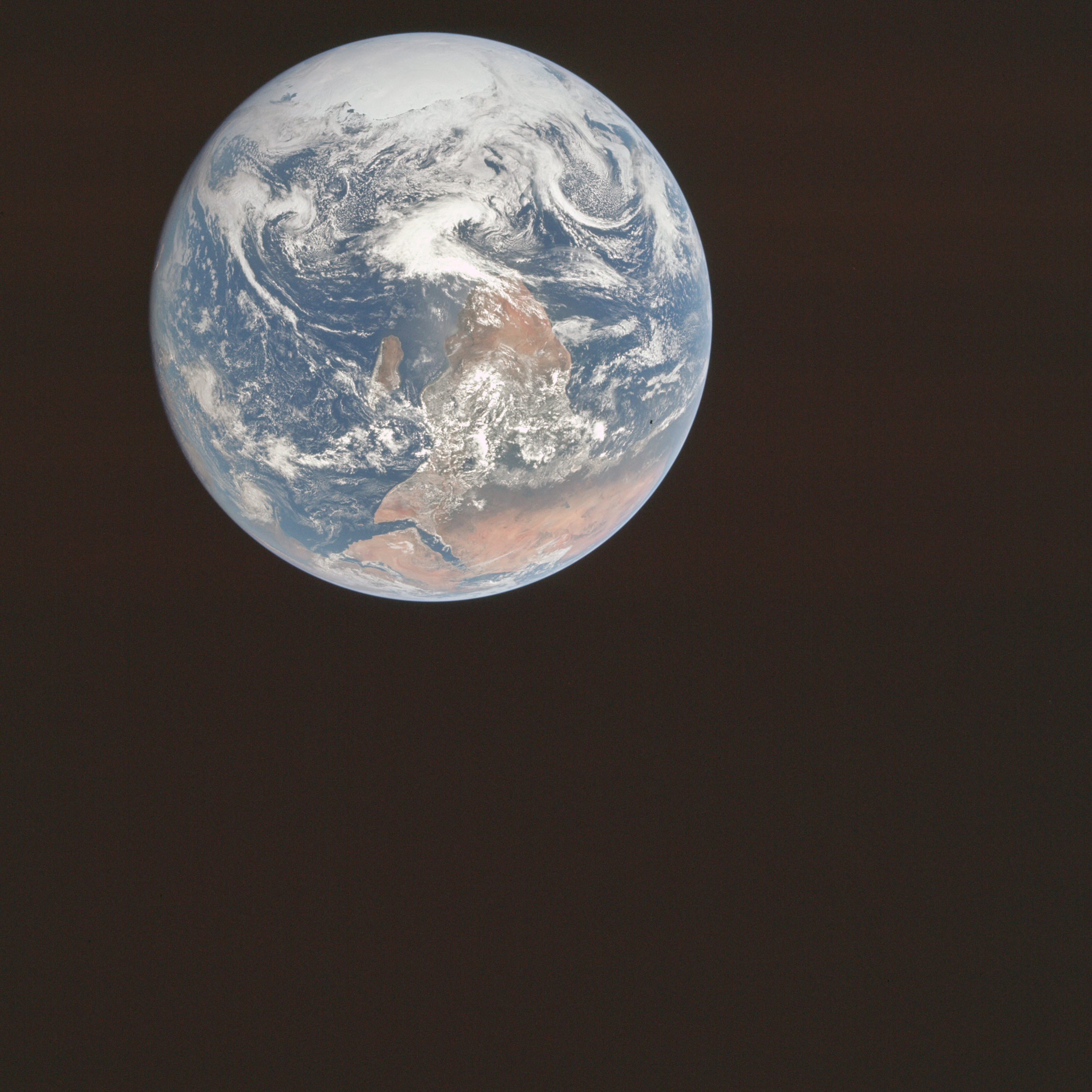
In space, after all, there is no “up” or “down” – and yet, our preconceptions of which cardinal direction goes where is so strong that in 1972, when NASA astronauts took the now-iconic “Blue Marble” photo that showed the Earth with Antarctica at the top, the agency chose to flip it upside down before publication to avoid confusing people.

The original Blue Marble shot, with Antarctica at the top.
Image Credit: NASA
And in perhaps our most common interaction with maps – the use of GPS systems on our phones or in our cars – North is barely important at all. In those systems, the layout is dynamic, oriented towards our direction of travel.
ADVERTISEMENT
In the end, then, perhaps “North at the top” is less of a rule and more of a blip. It was certainly popular for a long time – but after centuries of technological advancements, it seems we’ve ended up right where we began back in ancient times: with ourselves in the middle, and our destination at the top.
Time, like mappa mundae, is a circle after all.
All “explainer” articles are confirmed by fact checkers to be correct at time of publishing. Text, images, and links may be edited, removed, or added to at a later date to keep information current.
Source Link: Why Is North "Up" On Maps?