• Email Us: [email protected]
  • Contact Us: +1 718 874 1545
  • Skip to main content
  • Skip to primary sidebar

Medical Market Report

  • Home
  • All Reports
  • About Us
  • Contact Us

Why Is Oklahoma Shaped Like A Cooking Pot With A Panhandle?

July 18, 2023 by Deborah Bloomfield

The story of how Oklahoma’s borders ended up looking like a cooking pot with a handle is one steeped in the state’s unique history and the legacy of slavery.

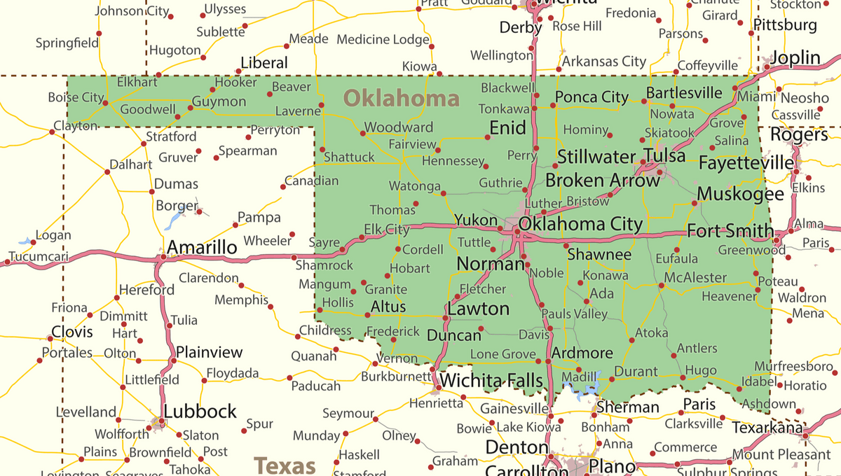
Take a look at a map of the US and you’ll see the shape of Oklahoma is relatively rectangular-shaped except for a 106-kilometer (66-mile) strip of land awkwardly poking out of its top left corner towards New Mexico. It quite literally sticks out like a sore thumb. 

Advertisement

Beneath this band of land, known as the Oklahomo Panhandle, is the state of Texas which looks as if it could encompass this strip quite comfortably. However, drawing up borders is rarely that simple.

It all starts when Texas formally declared independence from Mexico in 1836. The Republic of Texas existed as an independent nation until 1845 when it was admitted to the Union as a slave state. 

However, under the Missouri Compromise of 1820, slavery was forbidden north of the 36°30′ parallel. In order to not fan the flames of this growingly contentious issue, Texas snipped off a few dozen kilometers from its northernmost border, which was largely uninhabited except for a few herding communities.

And so, this unusual strip of land was left hovering like a landlocked island.

Advertisement

By the 1880s, the strip was declared public domain and subject to “squatter’s rights,” causing a flood of immigration. The area was known as a Public Land Strip but became nicknamed No Man’s Land since it was essentially a lawless zone, run by self-governing collectives of squatters and ranchers who often ruled by mob justice and vigilante justice. 

The settlements grew into “squatter towns,” but little farming took place, owing to the lack of money in the area and its distance from important trade hubs. 

By 1890, it became apparent to the central government that the situation needed to be resolved. The Oklahoma Organic Act of 1890 assigned Public Land Strip to the new Oklahoma Territory and, in 1907, it became fully unified into the state of Oklahoma.  

The hard times for the Oklahoma Panhandle were not over yet, however. The infamous droughts of the 1930s severely impacted this strip of land, effectively turning the Panhandle into the epicenter of the Dust Bowl. Death, poverty, and desperation quickly followed. If you want a vivid illustration of how grim this time was in Oklahoma, look no further than John Steinbeck’s 1939 novel The Grapes of Wrath.

Advertisement

Even today, the Oklahoma Panhandle’s exceptional history can still be seen. The Panhandle has a population of just 29,000, less than 1 percent of the state’s total population, and the rate of people living in poverty is higher than the national average.

Deborah Bloomfield
Deborah Bloomfield

Related posts:

  1. GM extends Michigan plant shutdown over Bolt EV recall
  2. German conservatives raise spectre of far-left rule ahead of election
  3. NBA-‘We’re here for him’: Coach says Nets’ Irving misses Brooklyn practice
  4. Why Do Some Easter Island Moai Have Red Hats On?

Source Link: Why Is Oklahoma Shaped Like A Cooking Pot With A Panhandle?

Filed Under: News

Primary Sidebar

  • Pioneering “Pregnancy Test” Could Identify Hormones In Skeletons Over 1,000 Years Old
  • The First Neolithic Self-Portrait? Stony Human Face Emerges In 12,000-Year-Old Ruins At Karahan Tepe
  • Women Are Diagnosed With ADHD 5 Years Later Than Men, Even With Worse Symptoms
  • What Is Cryptozoology? We Explore The History And Mystery Of This Controversial Field
  • The Universe’s “Red Sky Paradox” Just Got Darker: Most Stars Might Never Host Observers
  • Uranus And Neptune May Not Be “Ice Giants” But The Solar System’s First “Rocky Giants”
  • COVID-19 Can Alter Sperm And Affect Brain Development In Offspring, Causing Anxious Behavior
  • Why Do Spiders’ Legs Curl Up Like That When They’re Dead?
  • “Dead Men’s Fingers” Might Just Be The Strangest Fruit On The Planet
  • The South Atlantic’s Giant Weak Spot In The Earth’s Magnetic Field Is Growing
  • Nearly Half A Century After Being Lost, “Zombie Satellite” LES-1 Began Sending Signals To Earth
  • Extinct In the Wild, An Incredibly Rare Spix’s Macaw Chick Hatches In New Hope For Species
  • HUNTR/X Or Giant Squid? Following Alien Claims, We Asked Scientists What They Would Like Interstellar Object 3I/ATLAS To Be
  • Flat-Earthers Proved Wrong Using A Security Camera And A Garage
  • Earth Breaches Its First Climate Tipping Point: We’re Moving Into A World Without Coral Reefs
  • Cheese Caves, A Proposal, And Chance: How Scientists Ended Up Watching Fungi Evolve In Real Time
  • Lab-Grown 3D Embryo Models Make Their Own Blood In Regenerative Medicine Breakthrough
  • Humans’ Hidden “Sixth Sense” To Be Mapped Following $14.2 Million Prize – What Is Interoception?
  • Purple Earth Hypothesis: Our Planet Was Not Blue And Green Over 2.4 Billion Years Ago
  • Hippos Hung Around In Europe 80,000 Years Later Than We Thought
  • Business
  • Health
  • News
  • Science
  • Technology
  • +1 718 874 1545
  • +91 78878 22626
  • [email protected]
Office Address
Prudour Pvt. Ltd. 420 Lexington Avenue Suite 300 New York City, NY 10170.

Powered by Prudour Network

Copyrights © 2025 · Medical Market Report. All Rights Reserved.

Go to mobile version