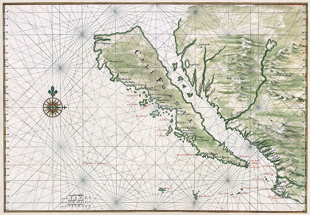
If you take a glance at maps produced in the 17th and 18th centuries CE, you may notice something unusual about California. For centuries, it was depicted as an island.
ADVERTISEMENT GO AD FREE
Old maps are pretty fascinating things to take a look at. If they don’t have phantom islands or warnings of lizard people, unicorns, and mermen, there’s still a good chance they’ll have an interesting mistake or two, from before we mapped the world as well as we have now.
When California was first put on maps by cartographers, including Gerard Mercator of Mercator projection fame in 1538, it was depicted as a peninsula. This lasted for much of the 1500s, with cartographers diligently copying the depiction from map to map. But towards the end of the century, Antonia de la Ascensión – who accompanied Spanish explorer, soldier, and colonizer Sebastián Vizcaíno on a trip to what is now the USA’s west coast – made a mistake that took centuries to correct.
“The whole Kingdom of California discovered on this voyage, is the largest island known,” he wrote following the apparently somewhat flawed exploration, adding “it is separated from the provinces of New Mexico by the Mediterranean Sea of California.”
It wasn’t only Antonia de la Ascensión who made this strange error. Juan de Iturbe, who explored parts of California in 1615, and Antonia Vázquez de Espinosa both made the same claim, with Vázquez de Espinosa insisting “California is an island, and not continental, as it is represented on the maps made by the cosmographers.”

California depicted as an island in a 1650 map by Johannes Vingboons.
Maps of this time were not set in stone, and had competing views on how the Earth looked. But the California problem became much worse in 1650, when leading French cartographer Nicolas Sanson included the island of California in his own map. Given his influence, other cartographers began diligently copying the same error onto their own maps. And so the mistake, and myth of California as an island, continued to propagate in maps into the 18th century until further exploration proved that California was not an island, and Baja California is in fact a peninsula.
So, why did the mistake happen? Part of it may have been the popular 1510 Spanish romance novel Las Sergas de Esplandián, which includes an imaginary island ruled by Queen Califia.
ADVERTISEMENT GO AD FREE
“Know, that on the right hand of the Indies there is an island called California very close to the side of the Terrestrial Paradise; and it is peopled by Black women, without any man among them, for they live in the manner of Amazons,” a translation of the work reads. “They had beautiful and robust bodies, and were brave and very strong. Their island was the strongest of the World, with its steep cliffs and rocky shores. Their weapons were golden and so were the harnesses of the wild beasts that they were accustomed to taming so that they could be ridden, because there was no other metal in the island than gold.”
Another factor may be a little wishful thinking, as a passage would have been useful for settlers and traders of the time. It may also be the case that Antonia de la Ascensión was motivated by negating Francis Drake’s claim of New Albion for the English, with him instead landing on an island away from the mainland.
As for why it continued, that’s a little lesson in trusting authoritative mapmakers against emerging evidence to the contrary.
Source Link: Why Was California Depicted As An Island For Centuries?