April and May temperature records have been smashed across Asia this year, and in many other places as well. The World Meteorological Organization (WMO) has warned that it’s likely to be just the start of a series of heat waves everyone needs to prepare for now.
Along with the rising trend caused by the build-up of heat-trapping gasses in the atmosphere, the climate is shaped on an annual timescale by a number of cycles. The most powerful of these is the El Niño/La Niña Sothern Oscillation (ENSO). El Niños are characterized by warmer waters off the western Americas and higher air pressure in Darwin than in Tahiti. La Niñas are colder in the eastern Pacific, accompanied by a northward push of the jet stream.
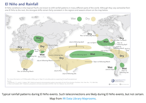
The effects of each vary by place – El Niños mean droughts in Australia, Brazil, and southern Africa but wet weather in central Asia and along the coasts of North and South America. La Niñas usually bring the reverse. For the planet as a whole, however, El Niño years are hotter than neutral years, which in turn have more heat than La Niñas.
Every El Niño is different, but patterns like this of wet and dry are typical, but most areas are hotter. Image Credit: Data Library Maprooms via WMO
An El Niño has yet to be confirmed for this year but is considered increasingly likely. The WMO’s statement reads; “There is a 60 percent chance for a transition from ENSO-neutral to El Niño during May-July 2023, and this will increase to about 70 percent in June-August and 80% between July and September.”
The percentages might be higher were it not for the fact the Northern Hemisphere spring is the hardest time of year for long-term weather forecasting. The WMO does not have the confidence to predict the length of the El Niño, should it come, nor the intensity. Typically, El Niños last 9-12 months. Some are mild, but strong ones such as 1998 and 2014-2016 have been associated with some of the most extreme weather ever experienced.
“The world should prepare for the development of El Niño, which is often associated with increased heat, drought or rainfall in different parts of the world,” said WMO Secretary-General Prof. Petteri Taalas in the release.
The world has been in La Niña or neutral phase for the last three years, yet has still been hotter than even the most intense El Niño year pre-2014. So with carbon dioxide levels 5 parts per million higher than during the last El Niño, this year can be expected to break records at local, regional, and probably global scales.
“We just had the eight warmest years on record, even though we had a cooling La Niña for the past three years and this acted as a temporary brake on global temperature increase. The development of an El Niño will most likely lead to a new spike in global heating and increase the chance of breaking temperature records,” Taalas said.
For some places, the arrival of an El Niño may come as a relief, at least initially. But the welcome will fade if it lasts anything like as long as the recent La Niñas. Taalas noted “It might bring respite from the drought in the Horn of Africa and other La Niña- related impacts but could also trigger more extreme weather and climate events. This highlights the need for the UN Early Warnings for All initiative to keep people safe.”
Many of the areas likely to be most affected can do little to prepare for an El Niño. For others adjusting crop planting recommendations, releasing or preserving dam levels as applicable or just stocking up on disaster relief supplies are options.
Source Link: World Meteorological Organization Warns El Niño Is Likely, And We Should Prepare
