Iceland’s recent bout of volcanism is still going strong, with new imagery and drone footage showing the ongoing volcanic activity on the Reykjanes Peninsula in all its beautiful and terrifying glory.
The eruption began from the Fagradalsfjall volcanic system between Stóra-Skógfell and Sýlingarfell at 23:14 on November 20, according to the Icelandic Met Office. By November 25, the authority said the lava flow was “on par with the most vigorous eruptions at Fagradalsfjall.”
The latest update at the time of writing said the flow of lava is still going, although it had slightly subsided over the week, and eruptive activity has been steady over the last 24 hours. Lava, as well as plumes of volcanic gas, continues to gush out of a 3-kilometer (1.9-mile) fissure, creating a mesmerizing display that was captured by an aerial drone.
The footage of the volcanic field was shot on the night of November 22 by Isak Finnbogason near the fishing town of Grindavík, not far from the Blue Lagoon geothermal spa that’s popular with tourists and locals alike.
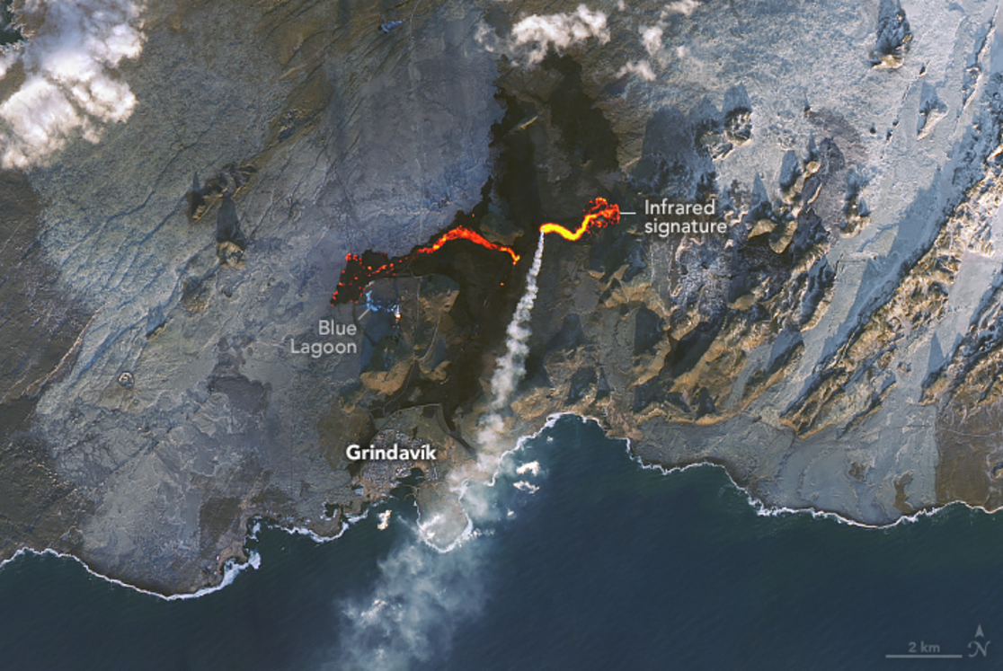
Imagery (below) captured by the Landsat 9 satellite on November 24 and shared by NASA Earth Observatory shows a “bird’s eye view” of the situation, highlighting just how close the lava stream came to the famous Blue Lagoon.
Understandably, the resort was forced to shut down and the facility won’t be open again until at least December 4, at which point the situation will be reassessed.
According to Visit Reykjanes, lava from the central crater managed to reach the Blue Lagoon’s car park and caused damage to a small service building. Workers blasted the nearby lava streams with water in an attempt to cool it down.
Satellite image shows the volcanic eruption on Iceland’s Reykjanes Peninsula on November 24, 2024.
Image credit: NASA Earth Observatory image by Michala Garrison, using Landsat data from the USGS and VIIRS day-night band data from the Suomi National Polar-orbiting Partnership
Precariously placed on the Mid-Atlantic Ridge in the North Atlantic Ocean, Iceland was literally made by volcanoes, although this latest spurt of activity is exceptional. It’s the seventh such event that’s rocked the Reykjanes peninsula since December 2023. Prior to 2021, the Fagradalsfjall volcano system in the area was dormant for 815 years.
The flare-up is especially worrying because this southwestern part of the island is home to 70 percent of the country’s population and much of its infrastructure, including its only international airport and several powerplants.
A study, published in June 2024, found that the recent flurry of activity at Fagradalsfjall could be part of a pattern of volcanic activity in the area that could last decades, if not centuries. However, the researchers emphasized that these events are notoriously difficult to predict, and it remains too early to discern a clear pattern.
“Nature is never regular. We don’t know how long and how frequently it will continue for the next ten or even a hundred years. A pattern will emerge, but nature always has exceptions and irregularities,” Ilya Bindeman, author of the 2024 study and a volcanologist at the University of Oregon, said in a statement.
“When you witness a volcanic eruption, you can feel that these are the massive forces of nature, and you yourself are very small. These events are ordinary from the geological scale, but from the human scale, they can be devastating,” Bindeman added.
Source Link: New Drone Footage Shows Fire and Fury Over Iceland’s Volcanic Landscapes
