Some of the world’s largest earthquakes and tsunamis have originated from the Cascadia Subduction Zone, a 1,127-kilometer (700-mile) stretch that runs from northern California up to British Columbia. Here, the Pacific Ocean floor is subducting under North America – and when the fault periodically locks and releases, it can unleash devastating megathrust earthquakes and record-breaking waves.
Megathrust earthquakes are the most powerful on Earth and they arise from subduction zones, where one of Earth’s plates is slipping over another. When rock on a convergent plate boundary gets compressed and bent, it builds up elastic energy. When this gets too much, there is an abrupt release as the overriding plate slides up the fault.
As the plate slips and releases, it generates enormous amounts of energy that goes out into the surrounding seawater. That energy displaces water as it rises to the sea surface, raising it above the normal surface level. It then comes crashing down thanks to gravity, sending the energy shooting out horizontally in the form of a tsunami.
The resulting waves can travel over 804 kilometers per hour (500 miles per hour). If they’re out in the open ocean they may just disappear, but if close to land they can be incredibly deadly.
This is because in shallow water something called wave shoaling occurs, where by the energy gets compressed, creating tsunami waves that are slower but much, much higher – sometimes rising to 30.5 meters (100 feet) tall. When these make ground, they can level buildings as they tear inland, and the debris and any humans caught up in the disaster are then at risk of being swept out as the water retreats again.

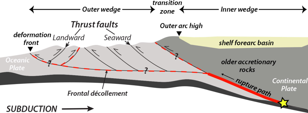
A schematic cross section of the Cascadia Subduction Zone shows the ocean floor plate (light grey) moving under the North American continental plate.
Image credit: U.S. Geological Survey
The destructive power of megathrust faults like the Cascadia Subduction Zone means they’re of great interest to scientists, as when it comes to tsunamis, early detection is one of our best forms of defense. This was demonstrated in 2011 when the Tohoku Earthquake and subsequent tsunami overcame seawalls designed to defend against such a natural disaster, claiming over 18,000 lives and causing a significant nuclear accident as it disabled three reactors at the Fukushima Daiichi Nuclear Power Station.
In an effort to establish better warning systems for the Cascadia Subduction Zone, a new study used advanced geophysical instruments to provide the first comprehensive survey of the zone.
All Cascadia residents should prepare to experience a powerful and potentially damaging subduction zone earthquake in their lifetimes.
CREW
“The models currently in use by public agencies were based on a limited set of old, low-quality 1980s-era data,” said research lead Suzanne Carbotte, a marine geophysicist at Columbia University’s Lamont-Doherty Earth Observatory, in a statement. “The megathrust has a much more complex geometry than previously assumed. The study provides a new framework for earthquake and tsunami hazard assessment.”
One of the key findings centered around the segmentation of the fault, which is now thought to be made up of at least four sections that may be shielded from the movements of those surrounding them. This can help us to understand past events including the megathrust earthquake that happened in January 1700, a magnitude 9 event that created a tsunami that reached as far as Japan.

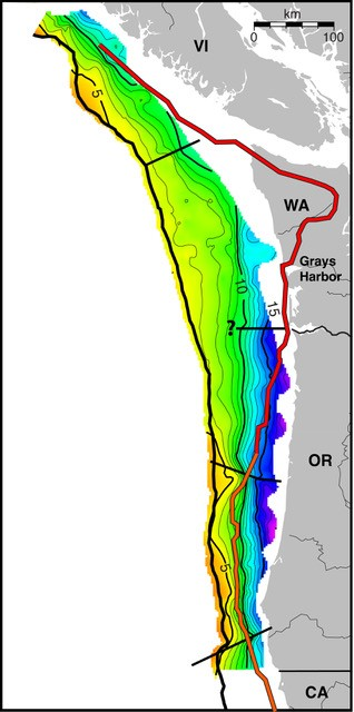
Sub-seafloor map of the Cascadia Subduction Zone, showing depth of the fault between the eastward-moving Juan de Fuca place and the North American plate going from shallow depths (yellow/orange) to the deepest (blues/purples). The diagonal black lines show the segments of the zone. The wavy red line shows the seaward edge of rigid continental rocks that apparently cause the zone to break into these segments.
Image credit: Modified from Carbotte et al., Science Advances, 2024
The 1700 megathrust earthquake is considered to be one of the largest in North America’s history, and we’ve long wondered if it involved the entire fault or just a segment. According to the Cascadian Region Earthquake Workgroup, (CREW) the best available evidence suggests such an event likely occurs every 500 to 600 years, but they can be as frequent as 100 to 300 years, “meaning, all Cascadia residents should prepare to experience a powerful and potentially damaging subduction zone earthquake in their lifetimes.”
Understanding the megathrust earthquake and tsunami threat potential of the Cascadia Subduction Zone is “still a work in progress” for the team behind this latest research, but as we learn more about this complex feature of North America’s geologic makeup, it’s hoped we can better prepare for future natural disasters.
The study is published in the journal Science Advances.
Source Link: Megathrust Earthquakes And The World’s Largest Tsunamis: What Is The Cascadia Subduction Zone?